
Old Ordnance Survey Inch to the Mile Maps
These maps normally cover an area of about 18 miles by 12 miles and are especially good at showing railways, roads and canals, and at giving
a broad view of a wider area. Each includes an introduction and a more detailed map of a small town or village.
They are available through our On-line Mapshop
 Here is information about Sheet 325:
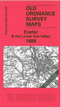
One Inch Sheet 325 Exeter & the Lower Exe Valley 1888 - published 2004; intro by Richard Oliver. ISBN.978-1-84151-613-4
This Inch to the Mile map covers the area of Devon centred on the cathedral city of Exeter. Coverage
stretches from Yeoford and Tedburn St Mary eastward to Whimple, and from Bradninch southward to Exminster. On the reverse is an extract from Devon Sheet 69.11, showing the village of
Whimple in detail, complete with directory.
It is not possible to list the many hamlets, farmsteads and other topographical features shown on these maps. However, you may find it useful if we list the towns and
principal villages or church parishes that are included on this map. Links are given for those for which detailed large-scale maps are also available.
Devon: Alphington, Aylesbeare, Bradninch, Brampford Speke, Bridford, Broad Clyst, Cadbury, Clyst Honiton, Clyst Hydon, Clyst St George, Clyst St Lawrence, Crediton, Doddiscombsleigh,
Dunchideock, Dunsford, Exeter, Exminster, Farringdon, Holcombe Burnell, Huxham, Nether Axe, Newton St Cyres, Pinhoe, Plymtree,
Poltimore, Rockbeare, Sandford, Shillingford, Shobrooke, Silverton, Sowton, Stockleigh Pomeroy, Stoke Canon, Talaton, Tedburn St Mary, Thorverton,
Topsham, Up Exe, Upton Hellions, Upton Pyne, Whimple, Whitestone, Woodbury.
Index maps are available showing the areas covered by the Inch to the Mile maps. Go to This page
You can order maps direct from our On-line Mapshop. For a full list of Inch to the Mile maps go to the Inch to the Mile page,
where you will also find details of prices. For information on the rest of the series, go to The Index Page.
Alan Godfrey Maps, Prospect Business Park, Leadgate, Consett, Co Durham, DH8 7PW / sales@alangodfreymaps.co.uk / 16 April 2011