
Old Ordnance Survey Inch to the Mile Maps
These maps normally cover an area of about 18 miles by 12 miles and are especially good at showing railways, roads and canals, and at giving
a broad view of a wider area. Each includes an introduction and a more detailed map of a small town or village.
They are available through our On-line Mapshop
 Here is information about Sheet 207:
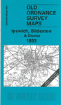
One Inch Sheet 207 Ipswich, Bildeston & District 1893 - published Dec 2005; intro by Robert Malster. ISBN.978-1-84151-849-7
This One Inch to the Mile map covers the area around Ipswich, stretching from Bildeston eastward to the outskirts of Woodbridge, and from Hadleigh and Bentley northward to Needham Market.
On the reverse is a detailed map of the small town of Bildeston, together with a directory.
It is not possible to list the many hamlets, farmsteads and other topographical features shown on these maps. However, you may find it useful if we list the towns and
principal villages or church parishes that are included on this map. Links are given for those for which detailed large-scale maps are also available.
Suffolk: Akenham, Aldham, Ashbocking Green, Badley, Barham, Battisford, Baylham, Bedfield, Bentley, Bildeston, Bramford, Brightwell, Bucklesham, Burgh, Burstall,
Capel St Mary, Chattisham, Chelmondiston, Claydon, Clopton, Coddenham, Comb, Copdock, Culpho, Dallinghoo, Debach, Elmsett,
Flowton, Freston, Gosbeck, Great Bealings, Great Blakenham, Great Wenham, Grundisburgh, Hadleigh, Hasketon, Hemingstone, Hintlesham, Hitcham, Ipswich,
Kersey, Kesgrave, Layham, Levington, Little Bealings, Little Blakenham, Little Wenham, Martlesham, Nacton, Naughton, Nedging, Needham Market, Nettlestead,
Offton, Playford, Polstead, Raydon, Rushmere, Senier, Shelley, Somersham, Sproughton, Swilland, Tuddenham, Washbrook, Wattisham,
Westerfield, Whatfield, Wherstead, Whitton cum Thurlston, Willisham, Witnesham, Woolverstone.
Index maps are available showing the areas covered by the Inch to the Mile maps. Go to This page
You can order maps direct from our On-line Mapshop. For a full list of Inch to the Mile maps go to the Inch to the Mile page,
where you will also find details of prices. For information on the rest of the series, go to The Index Page.
Alan Godfrey Maps, Prospect Business Park, Leadgate, Consett, Co Durham, DH8 7PW / sales@alangodfreymaps.co.uk / 16 April 2011