
Old Ordnance Survey Inch to the Mile Maps
These maps normally cover an area of about 18 miles by 12 miles and are especially good at showing railways, roads and canals, and at giving
a broad view of a wider area. Each includes an introduction and a more detailed map of a small town or village.
They are available through our On-line Mapshop
 Here is information about Sheet 199:
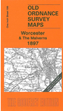
One Inch Sheet 199 Worcester & The Malverns 1897 - published 2006; intro Malcolm Nixon. ISBN.978-1-84151-917-3
This Inch to the Mile map covers much of south Worcestershire together with part of Herefordshire, with Worcester and the Malvern Hills quite central features of the map. Coverage stretches from Acton Beauchamp eastward to Pershore, and from Worcester southward to Upton on Severn.
The map is an excellent accompaniment to our larger scale maps for the Malverns and Worcester. On the reverse we include a detailed map of Upton on Severn town centre.
It is not possible to list the many hamlets, farmsteads and other topographical features shown on these maps. However, you may find it useful if we list the towns and
principal villages or church parishes that are included on this map. Links are given for those for which detailed large-scale maps are also available.
Herefordshire: Acton Beauchamp, Bosbury, Castle Frome, Coddington, Colwall, Cradley, Evesbatch, Mathon, Stanford Bishop, Tedstone Delamere, Whitbourne.
Worcestershire: Alfrick, Besford, Birlingham, Bransford, Bredicot, Broadwas, Churchill, Cotheridge, Croome D'Abitot, Crowle, Defford, Earls Croome, Eckington, Great Malvern, Hallow, Hanley Castle, Hill Croome, Hindlip,
Huddington, Kempsey, Leigh, Little Malvern, Lulsley, Madresfield, Malvern Link, Malvern Wells, Newland, Norton, Peopleton, Pershore, Pirton, Powick, Severn Stoke, Spetchley, Stoulton, Suckley, Tibberton,
Upton Snodsbury, Upton upon Severn, Warndon, Welland, White Ladies Aston, Whittington, Worcester.
Index maps are available showing the areas covered by the Inch to the Mile maps. Go to This page
You can order maps direct from our On-line Mapshop. For a full list of Inch to the Mile maps go to the Inch to the Mile page,
where you will also find details of prices. For information on the rest of the series, go to The Index Page.
Alan Godfrey Maps, Prospect Business Park, Leadgate, Consett, Co Durham, DH8 7PW / sales@alangodfreymaps.co.uk / 16 April 2011