
Old Ordnance Survey Inch to the Mile Maps
These maps normally cover an area of about 18 miles by 12 miles and are especially good at showing railways, roads and canals, and at giving
a broad view of a wider area. Each includes an introduction and a more detailed map of a small town or village.
They are available through our On-line Mapshop
 Here is information about Sheet 155:
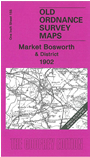
One Inch Sheet 155 Market Bosworth & District 1902 - published 2006; intro by Barrie Trinder. ISBN.978-1-84151-897-8
This One Inch to the Mile map covers much of western Leicestershire, together with a smaller portion of Warwickshire. Coverage stretches
from Polesworth eastward to Bradgate Park and EWnderby, and fromCoalville and Moira southward to Atherstone. Transport features include the Ashby de la Zouch Canal, Ashby & Nuneaton Joint Railway, Enderby Branch. A
major feature is the detailed map of Market Bosworth which we include on the reverse, complete with directory.
It is not possible to list the many hamlets, farmsteads and other topographical features shown on these maps. However, you might find it useful if we here list the majority of the principal villages
and church parishes that are included on this map. Links are given for those for which detailed large-scale maps are also available.
Derbyshire: Netherseal, Overseal.
Leicestershire: Appleby Magna, Atterton, Bagworth, Bardon, Barlestone, Barton in the Beans, Bilstone, Cadeby, Carlton, Chilcote. Coalville, Congerstone, Dadlington, Earl Shilton, East Leioester Forest,
Enderby, Fenny Drayton, Groby, Heather, Hugglescote & Donington, Huncote, Ibstock, Kirkby Mallory, Kirkby Muxloe, Market Bosworth, Markfield, Measham, Nailstone, Newbold Verdon, Newtown Linford, Normanton le Heath, Norton juxta Twycross,
Oakthorpe, Odstone, Orton on the Hill, Osbaston, Packington, Peckleton, Ratby, Ratcliffe Culey, Ravenstone with Snibston, Shackerstone, Sheepy Magna, Sheepy Parva, Shenton, Snarestone, Stanton under Barton, Stapleton, Stoke Golding,
Stretton en le Field, Sutton Cheney, Swepstone, Thornton, Thurlaston, Twycross, Upton, Whitwick, Willesley, Witherley, Woodhouse.
Staffordshire: Thorpe Constantine.
Warwickshire: Atherstone, Austrey, Baddesley Ensor, Dordon, Grendon, Newton Regis, Polesworth, Seckington, Shutington, Warton.
Index maps are available showing the areas covered by the Inch to the Mile maps. Go to This page
You can order maps direct from our On-line Mapshop. For a full list of Inch to the Mile maps go to the Inch to the Mile page,
where you will also find details of prices. For information on the rest of the series, go to The Index Page.
Alan Godfrey Maps, Prospect Business Park, Leadgate, Consett, Co Durham, DH8 7PW / sales@alangodfreymaps.co.uk / 16 April 2011