
Old Ordnance Survey Inch to the Mile Maps
These maps normally cover an area of about 18 miles by 12 miles and are especially good at showing railways, roads and canals, and at giving
a broad view of a wider area. Each includes an introduction and a more detailed map of a small town or village.
They are available through our On-line Mapshop
 Here is information about Sheet 101:
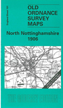
One Inch Sheet 101 North Nottinghamshire 1906 - published 2001; intro by Steph Mastoris. ISBN.978-1-84151-279-2
This Inch to the Mile map covers the area from Shireoaks and Worksop eastward to Gainsborough and Knaith, and from Bawtry southward to Welbeck Abbey. Retford is near the centre of the map.
The River Trent winds along the eastern edge, and the Chesterfield Canal weaves its way across the map. On the reverse we include a detailed map of Shireoaks, which includes the station, canal and part of Shireoaks Colliery.
It is not possible to list the many hamlets, farmsteads and other topographical features shown on these maps. However, you may find it useful if we list the towns and
principal villages or church parishes that are included on this map. Links are given for those for which detailed large-scale maps are also available.
Lincolnshire: Gainsborough, Knaith, Lea, Morton, Newton upon Trent, Thonock, Walkeith.
Nottinghamshire: Askham, Babworth, Barnby Moor, Bawtry, Beckingham, Blyth, Bole, Carlton in Lindrick, Clarborough, Clayworth, Cottam, Dunham, East Drayton, East Retford,
Eaton, Elkesley, Everton, Gamston, Gringley on the Hill, Grove, Harworth, Hayton, Headon, Hodsock, Laneham, Littleborough, Lound, Mattersey, North Leverton with Habblesthorpe, North Wheatley,
Ragnall, Ranskill, Saundby, Scaftworth, Scrooby, South Leverton, South Wheatley, Sturton le Steeple, Styrrup, Sutton, Torworth, Treswell, Walkeringham, West Burton, West Drayton, Wiseton, Worksop.
Yorkshire: Firbeck, Gildingwells, Letwell, Woodsetts.
Index maps are available showing the areas covered by the Inch to the Mile maps. Go to This page
You can order maps direct from our On-line Mapshop. For a full list of Inch to the Mile maps go to the Inch to the Mile page,
where you will also find details of prices. For information on the rest of the series, go to The Index Page.
Alan Godfrey Maps, Prospect Business Park, Leadgate, Consett, Co Durham, DH8 7PW / sales@alangodfreymaps.co.uk / 16 April 2011