Old Ordnance Survey Maps of Nottinghamshire

  • These detailed maps normally cover an area of about one and a half miles by one mile. Each map includes an introduction.
  • They are available through our On-line Mapshop

  • Here are the details of maps for Arnold:

  • Notts Sheet 38.06 Nottingham (Arnold & Daybrook) 1899 - published 2010; intro by Barrie Trinder. ISBN.978-1-84784-426-2

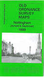
    This very detailed map covers Daybrook and part of Arnold, north of Nottingham.

    Coverage runs from Front Street Arnold westward toSunrise Farm and Sunrise Hill, and from Redhill Farm southward to Daybrook station. Features include the Front Street and High Street area of Arnold, Arnot Hill, Home Brewery, GNR railway with Daybrook station, Daybrook Works, St Paul's church, Cherryhill, White Hart pub, cemetery, Goodwood House, chapels etc. On the reverse we include an 1891 directory of Arnold.

    The map links up with Notts sheets 38.05 Bulwell to the west, 38.10 Sherwood to the south.


  • Follow this link for a complete list of our Nottinghamshire Series maps.
  • You can order maps direct from our On-line Mapshop. For other information and prices, and other areas, go to The Index Page.
  • Maps in the Godfrey Edition are taken from the 25 inch to the mile map and reduced to about 15 inches to the mile. For a full list of maps for the East Midlands, return to the East Midlands page.
    The Godfrey Edition / sales@alangodfreymaps.co.uk / 28 January 2018