
 Here are the details of maps for Wimbledon:

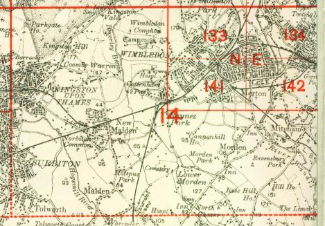
This detailed map covers the central and northern part of Wimbledon, with coverage stretching from Park Side eastward to the railway, and from the station northward to Wimbledon Park station.
Features include Wimbledon Hill Road and Wimbledon Hill with all buildings neatly shown, northern part of Wimbledon station, Wimbledon Park station, Wimbledon Park House, St Mark's church, St Mary's church, Wimbledon House, eastern fringe of Wimbledon Common, Cannizaro House, many houses in grounds etc. On the reverse we include a selection of street directory entries, including Alexandra Road, Church Road, High Street, Hill Road, Wimbledon Hill.
The map links up with London Sheets 123 Southfields to the north, 134 Tooting to the east, 141 S Wimbledon to the south and Surrey sheet 7.10 Wimbledon Common to the east.
 Follow this link for a complete list of our London maps .