
 Here are the details of maps for Tooting:

We have published two versions of this map, showing how the area developed across the years. Although in theory both maps cover the same area, coverage is less complete on the 1913 map, where the Surrey part of the map is left blank. Therefore, if you are buying only one of the maps I strongly advise the 1894 version..
The 1894 map covers the area from Wimbledon cemetery and Cromwell Road eastward to St Nicholas' church, Mitcham Road and Vant Road; and from Maskell Road and Huntspill Road southward to Cowper Road and Trevelyan Road. Features include Fountain Hospital; Lambeth, Wimbledon and Streatham cemeteries; Tooting Graveney, Merton Road, High Street, Mitcham Road, St Clement Danes Almshouses, tramways along Upper Tooting Road; a stretch of the River Wandle with industries, including Garratt Printing Works; Durnsford Lodge Hospital, Haydon's Road station. There are street directory extracts for Bickersteth Road, Blackshaw Road, Broadway, Garratt Lane, Hereward Road, Mellison Road, Merton Road, Mitcham Road.
The 1913 map (published by the OS as London Sheet XII.4) has Surrey - the area west of Lambeth Cemetery - left blank. We include the marginal London sheet XII.8 to the south as an inset for completion. This map excludes Haydons Road station, Wimbledon cemetery and the River Wandle area. However, it does now include the massive Grove Hospital, more extensive tramways, and more streets, especially between Backshaw Road and Garratt Lane. Street directories are included for Defoe Road, Garratt Lane, Tooting High Street, Mitcham Road, Selkirk Street and a few others.
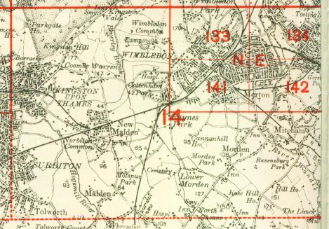
The map links up with London Sheets 124 Wandsworth Common to the north, 133 Wimbledon to the west, 135 West Streatham to the east, 142 Merton to the south.
 Follow this link for a complete list of our London maps .