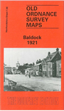
Hertfordshire Sheet 7.08 Baldock 1921 - published 1990; intro by Pamela Taylor. ISBN.978-0-85054-402-2 
This detailed map covers the Hertfordshire town of Baldock. Features include St Mary's church, High Street, White Horse Street, Church Street, Norton Street with all their buildings clearly marked; Clothall End,
Pembroke End, station, malthouses. Coverage extends north to Blackhorse Farm. On the reverse we include Inch to the Mile Sheet 221, from 1888; this covers the area from Hitchin, Stevenage and Baldock eastward to Buntingford.
Follow this link for a complete list of our Hertfordshire Series maps or go to the Chilterns page for other counties in the region.
You can order maps direct from our On-line Mapshop.
For other information and prices, and other areas, go to The Index Page
Maps in the Godfrey Edition are taken from the 25 inch to the mile map and reduced to about 15 inches to the mile.
For a full list of maps for England, return to the England page.
The Godfrey Edition / sales@alangodfreymaps.co.uk / 28 January 2018
 Here are the details of maps for Baldock: