Old Ordnance Survey Maps of Clerkenwell & King's Cross


We have published more than 1,800 maps in our series of Old Ordnance Survey Map reprints, some 300 of them in the London area. The maps are highly detailed. They are taken from the OS 1:2,500 (or 25 inch) maps and reduced to about 15 inches to the mile. They show streets with individual houses, tram tracks, railway tracks and even signals, factories, wharves and such details as fountains and water troughs. They will provide hours of fascination for historians and genealogists. The maps are neatly folded and each includes a specially written introduction to the area. Maps can be purchased on our On-line Mapshop where further information about titles is given.


Here are the details of maps for Clerkenwell:

  • London Sheet 50.1 Clerkenwell, King's Cross & The Angel 1871 - published 1991; introduction by Alan Godfrey
  • London Sheet 50.2 Clerkenwell, King's Cross & The Angel 1894 - published 1994; intro by Alan Godfrey
  • London Sheet 50.3 Clerkenwell, King's Cross & The Angel 1914 - published 1985, 2nd Edition 1994; intro by Isobel Watson

    These maps cover a busy and fascinating area. The three versions each cover the same area, stretching from Judd Street and King's Cross station eastward to Shepherdess Walk and Arlington Square; from the Regents Canal and Islington Green southward to Brunswick Square and Clerkenwell Road. The many features include Kings Cross station itself, part of St Pancras station (but not its approaches), the Foundling Hospital, Mount Pleasant Post Office, Clerkenwell and New River Head, Farringdon Street, Royal Agricultural Hall, Regents Canal, Wenlock Basin, City Road Basin, much of Finsbury. The countless streets include Pentonville Road, City Road, Percy Circus, part of Old Street, Upper Street, Clerkenwell Green, Roseberry Avenue, Northampton Square, Guilford Street, part of Grays Inn Road and many more.

    An index map showing the areas covered by this and adjacent maps is available here. 
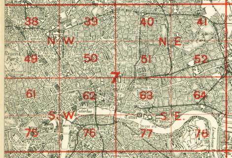
The map links up with Sheets 39 Highbury to the north, 49 Euston to the west, 51 Shoreditch to the east, 62 Holborn to the south.


    Follow this link for a complete list of our London maps .

    You can order maps direct from our On-line Mapshop. For other information and Prices, see Index Page.


    Maps in the Godfrey Edition are taken from the 25 inch to the mile map and reduced to about 15 inches to the mile. For a full list of maps for London, return to the London page

    The Godfrey Edition / godfreyedition@btinternet.com / 27 October 2005