
Old Ordnance Survey Maps of Telford
We have a range of detailed maps for Shropshire towns and we also cover the whole county at the Inch to the Mile scale.
All maps are available from our On-line Mapshop.
Shropshire (or Salop) County Council was formed in 1889. Since 2009 the county has been covered by two unitary authorities,
Telford and Shropshire
See This Page for a summary of the county's local government history.
 These are the maps we publish for Telford:
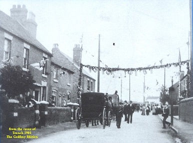
36.07 Trench 1901 published 2003; intro by Barrie Trinder
36.09a Wellington 1901 published 1990; intro by Barrie Trinder
36.09b Wellington 1925 published 2024; intro by Barrie Trinder
36.10 Hadley 1901 published 1991; intro by Barrie Trinder
36.11 Wrockwardine Wood, Wombridge & St George's 1901 published 2003; intro by Barrie Trinder
36.12 Granville Colliery & Priorslee Hall 1901 published 2024; intro by Barrie Trinder
36.14 Ketley 1901 published 1991; intro by Barrie Trinder
36.15 Oakengates South 1901 published 1995; intro by Barrie Trinder
43.02 Lawley 1901 published 1992; intro by Barrie Trinder
43.03 Malins Lee & Dark Lane 1901 published 2002; intro by Barrie Trinder
43.06 Horsehay & Dawley 1901 published 2007; intro by Barrie Trinder
43.07 Dawley Magna & Stirchley 1901 published 2001; intro by Barrie Trinder
43.10a Coalbrookdale & Lightmoor 1901 published 2006; intro by Barrie Trinder
43.10b Coalbrookdale & Lightmoor 1925 published 2024; intro by Barrie Trinder
43.11 Madeley Court 1901 published 1996; intro by Barrie Trinder
43.13 Buildwas Abbey & Benthall Edge 1901 published 2023; intro by Barrie Trinder
43.14a Ironbridge 1882 published 2014; intro by Barrie Trinder  43.14b Ironbridge 1901 published 1992; intro by Barrie Trinder
43.14c Ironbridge 1925 published 2025; intro by Barrie Trinder
43.15a Madeley South & Blists Hill 1901 published 2001; intro by Barrie Trinder
43.15b Madeley South & Blists Hill 1925 published 2024; intro by Barrie Trinder
44.01 Shifnal 1901 published 2004; intro by Barrie Trinder
51.02 Broseley 1901 published 1992; intro by Barrie Trinder
51.03 Coalport 1925 published 2024; intro by Barrie Trinder
43.14b Ironbridge 1901 published 1992; intro by Barrie Trinder
43.14c Ironbridge 1925 published 2025; intro by Barrie Trinder
43.15a Madeley South & Blists Hill 1901 published 2001; intro by Barrie Trinder
43.15b Madeley South & Blists Hill 1925 published 2024; intro by Barrie Trinder
44.01 Shifnal 1901 published 2004; intro by Barrie Trinder
51.02 Broseley 1901 published 1992; intro by Barrie Trinder
51.03 Coalport 1925 published 2024; intro by Barrie Trinder
For the rest of Shropshire go to the Shropshire page.
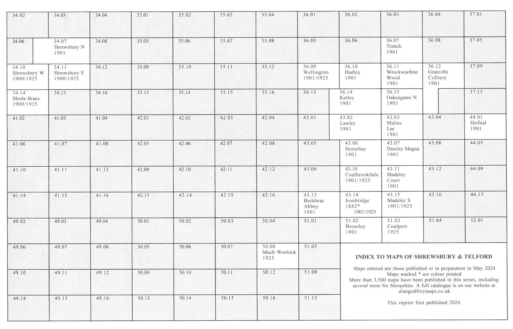
Here is an Index grid for Shrewsbury and Telford
We cover the whole of Shropshire in our Inch to the Mile series. These are the principal sheets for Telford:
152 Shrewsbury & The Wrekin 1904 - published 2003; intro by Barrie Trinder. Includes a map of Acton Burnell
153 Wolverhampton & Ironbridge 1898 - published 2001; intro by Barrie Trinder. Includes a map of Penkridge
For a full list of our one inch maps, go to the One Inch page
 Most maps in the Godfrey Edition are taken from the 25 inch to the mile map and reduced to about 15 inches to the mile.
For a full list of English maps, return to the England page
This list shows all our maps for the area. We try to keep a full range in print but inevitably some titles fall out of print from time to time.
These are noted in our On-line Mapshop.
Most maps in the Godfrey Edition are taken from the 25 inch to the mile map and reduced to about 15 inches to the mile.
For a full list of English maps, return to the England page
This list shows all our maps for the area. We try to keep a full range in print but inevitably some titles fall out of print from time to time.
These are noted in our On-line Mapshop.
Alan Godfrey Maps, Prospect Business Park, Leadgate, Consett, DH8 7PW. Tel 01207 583388
The Godfrey Edition / sales@alangodfreymaps.co.uk / 25 November 2024
 These are the maps we publish for Telford: