Old Ordnance Survey Maps of Middlesex

  • These detailed maps normally cover an area of about one and a half miles by one mile. Each map includes an introduction. The Middlesex maps link up with those for London to form a major series for the Greater London area. They are available through our On-line Mapshop

  • Here are the details of maps for New Barnet:

  • Middlesex Sheet 6.08 New Barnet 1896 - published 1985; intro by Pamela Taylor. ISBN.978-0-85054-034-5

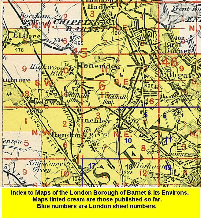
    "The focus of this map is New Barnet, a classic example of a suburb developing around a railway station" says Pamela Taylor in her introduction. New Barnet station was built on part of the Lyonsdown estate, the rest of which was then resold to the British Land Co for development. Our map captures the suburb that was the result, streets spreading out from the GNR railway and its station. Coverage extends south to the smaller East Barnet community, and west to Barnet Vale and to High Barnet terminus (then still a GNR branch). Other features include Underhill, Greenhill Park, Willenhall Park.

    The map links up with Middlesex Sheets 6.04 Monken Hadley to the north, 6.6.07 Barnet Common to the west, 7.09 East Barnet to the east and 6.12 Whetstone to the south.


  • Follow this link for a list of our maps for the London Borough of Barnet, or here for a complete list of our London maps .
  • You can order maps direct from our On-line Mapshop. For other information and prices, and other areas, go to The Index Page.
  • Maps in the Godfrey Edition are taken from the 25 inch to the mile map and reduced to about 15 inches to the mile. For a full list of maps for England, return to the England page.
    Alan Godfrey Maps, Prospect Business Park, Leadgate, Consett, Co Durham, DH8 7PW / sales@alangodfreymaps.co.uk / 15 January 2018