Old Ordnance Survey Maps of Middlesex

  • These detailed maps maps normally cover an area of about one and a half miles by one mile. Each map includes an introduction. The Middlesex maps link up with those for London to form a major series for the Greater London area. They are available through our On-line Mapshop

  • Here is information about the map for Barnet Common:

  • Middlesex Sheet 6.07 Barnet Common 1896 - published 1991; intro by Pamela Taylor. ISBN.978-0-85054-477-0

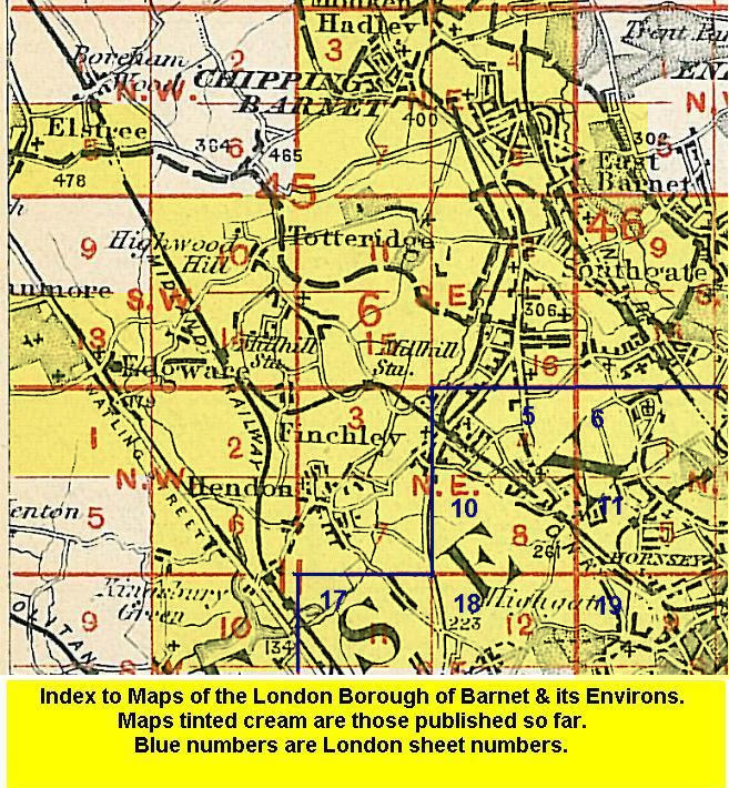
    This double-sided map covers the southern part of Chipping Barnet. A small portion of the High Street is in the NE corner of the main map and coverage includes Barnet Workhouse, Bells Hill and the southern fringe of the village. Cover then extends southward beyond Ducks Island to Dollis Brook, and westward along May's Lane to Totteridgevale Farm and Whitings Hill. Much of this area is referred to as Barnet Common. On the reverse we include half of Sheet 6.06 and this extends coverage westward to the village of Arkley, including St Peter's church, Arkley Hall and Rowley Green; then further west to Barnet Gate and Hyver Hall.

    The map links up with Middlesex Sheets 6.03 Barnet & Hadley to the north, 6.08 New Barnet to the east, and Sheets 6.10 Highwood Hill and 6.11 Totteridge to the south.


  • Follow this link for a list of our maps for the London Borough of Barnet, or here for a complete list of our London maps .
  • You can order maps direct from our On-line Mapshop. For other information and prices, and other areas, go to The Index Page.
  • Maps in the Godfrey Edition are taken from the 25 inch to the mile map and reduced to about 15 inches to the mile. For a full list of maps for England, return to the England page.
    Alan Godfrey Maps, Prospect Business Park, Leadgate, Consett, Co Durham, DH8 7PW / sales@alangodfreymaps.co.uk / 15 January 2018