 Lockerbie, a small Annandale town of around 4,000 people, was thrust onto the international stage on 21st December 1988 when a Boeing 747 flying from London Heathrow to New York JFK, the trans-Atlantic stage of Pan Am Flight 103 from Frankfurt to Detroit, was blown up in the air. The plane was flying at 31,000 ft and all 243 passengers and 16 crew died; 11 people were killed on the ground in Lockerbie, where some of the largest sections of the plane fell. These included large parts of the wings and adjacent fuselage, which destroyed much of Sherwood Crescent, creating a fireball and huge crater; 21 houses had to be demolished. Sherwood Crescent lies on the south side of Lockerbie, west of Main Street, in and about plot 648; it is approached by Sherwood Park, essentially a continuation of the Douglas Terrace shown here. Other major sections of the aircraft, including the engines, also landed on Lockerbie, and the flight deck and forward fuselage landed just east of the town. Some lighter debris was strewn across a wide area, some near the east coast of England. Libyan influence was suspected in this terrorist incident and one of Gadaffi's intelligence officers, Abdelbaset al-Megrahi, was eventually jailed.
This dreadful incident - which remains, in 2014 and hopefully for many years to come, Britain's most terrible terrorist outrage - is so shocking that a deep breath is necessary before we explore the rest of Lockerbie's history. We might then go briefly back as far as the 1st century, for the map notes the site of a bloody battle between Julius Agricola and the forces of the Scottish king, Corbredus Galdus. There were several forts and encampments in the area, and the area shown here as Earthworks (Site of) in plots 579-80 and 586-7 is nowadays believed to have been a Roman marching camp. However, no significant town developed, with border and clan disputes continuing until relatively recent times. Samuel Lewis, in his Topographical Dictionary, notes that "On the holm of Dryfe, half a mile below the former churchyard, there is still remaining an old thorntree pointing out the place of the celebrated fight on Dryfe Sands, between the Maxwells of Nithsdale and the Johnstons of Annandale, on the 7th December, 1593, when the former were defeated with great slaughter". This battle took place about half a mile N of this map, when Lord Maxwell's army of about 2,000 men gathered on the left bank of the Dryfe Water (which just creeps onto the map, top left, shortly before it flows into the Annan). They were provoked and then ambushed by Sir James Johnstone's men, a smaller force of perhaps 750, and in the ensuing rout Maxwell himself was killed.
The actual name of Lockerbie dates back to at least 1194, though it stood in the parish of Dryfesdale and comprised little more than a tower house and handful of cottages. Trade began to grow following the Union of the Crowns in 1603, which brought an end to the border raids and feuds. However this remained no more than a village, with just 76 adults recorded in 1684, and was basically a row of thatched cottage standing on a ridge, with the Flosh and Quaas lochs on either side. These lochs were later drained. From c.1680 the lamb sales began and the twice-yearly lamb fairs are said to have been the largest in Scotland. They were described by Lewis in the 1830s: "At this [Lammas] fair, which was formerly held at the foot of Lockerbie hill, from 70,000 to 80,000 lambs are now sold to various dealers; and so much has the business of late years increased, that the whole of that hill, of which the superiority was purchased from the corporation of Glasgow by Lady Douglas, of Lockerbie House, is now appropriated for the purpose. The Michaelmas fair is held, with the same restrictions, on the 2nd of October and is also numerously attended. There are markets for cattle, sheep and horses on the second Thursdays [of most months]. Markets are also held fortnightly during the winter for the sale of pork, in the purchase of which \'a31000 are often expended in one day, and fairs for hiring servants take place in April and Michaelmas".
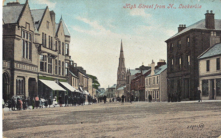
From the 1730s the Johnstones granted feus or leases for housing development along Mains Street and High Street, followed by Horsemarket or Bridge Street in the 1750s. Lockerbie now had some of the attributes of a town, and in late 1745 some of the Jacobite leaders, perhaps including Bonnie Prince Charlie, are said to have spent 'riotous evening' in the King's Arms, the Hotel at the junction of Victoria and High Streets. Later visitors would include Sir Walter Scott in 1813. The hotel slipped briefly into the national news in 1811 when a Jean Law from Carlisle, "having been accused of child murder and the concealment of the child", escaped from the building while awaiting transfer to the Dumfries county gaol. The hotel was extended in 1794 and given a major 'make-over' in the late 19th century with mock half-timbering and fancy balconies. The town's other early coaching inn was the Blue Bell (shown here simply as P.H. just S of the Town Hall), dating from c.1789. The hotel had stabling for thirty horses and the hounds of the Dumfriesshire Hunt were sometimes kennelled here. In 1794 it was described as lying "in the centre of the market town of Lockerbie, on the great turnpike and mail coach route from England into Scotland, is extremely convenient for posters, travellers and the frequent markets, the throngest in that part of the country", but these attractions were not enough to stop the first landlord, Isaac Mullender, from going bankrupt. Away from the main street through the town - part of the trunk route improved by Telford in the early 19th century - the only significant road in the early days was Bridge Street, running along the line of today's Station Road. It took its name from a bridge across a stream - for many years it crossed the railway on the level - and was notable for another stream running along it, with stone troughs for women to do their washing. In winter it would often freeze over, and the street became a virtual ice rink. Just to the north we note a well, Bessie's Well, though the original water supply may have been further east, on land utilised for the railway.
Lockerbie's position on the main England-Scotland road made it a natural site for inns, of which there were several. The only one mentioned here by name is the St Mungo Arms, dating from the late 19th century and at one time run by an ex-policeman who went bankrupt and whose wife then took him to court over the money she had put towards its purchase price. Somewhat older is the Black Bull, possibly dating from 1782; it was popular with French prisoners-or-war who were detained here during the Napoleonic wars. However, the temperance movement was strong and as late as 1905 a trade directory listed only one hostelry - the Cross Keys on Bridge Street - as an Inn, the rest preferring to be classified as hotels. Two of the latter, Hardie\rquote s on Union Street and Gardner's on High Street, were temperance institutions.
Lockerbie is in Dryfesdale parish and the parish church was originally beside Dryfe Water outside the town, but had been subject to repeated flooding; in 1608 there had been a violent squabble between a landowner and parishioners as the latter attempted to divert the river away. The church was flooded again in 1670 and an attempt to rebuild elsewhere, but still on the flood plain, was no more successful. In 1757 a site was granted in the growing town for a new church and a very plain, almost barn-like church was built. This was increasingly seen as inappropriate for a growing burgh and in 1896 it was replaced by a new Dryfesdale parish church in 1896, for which the foundation stone was laid by Arthur Johnstone Douglas, Provincial Grand Master of Dumfriesshire and a descendant of the laird who had originally granted the site. The church, "a boxy Gothic building, neither its height nor its steeple providing excitement" according to John Gifford, was designed by the local architect Frank James Chambers Carruthers. The church has a surprisingly decorative interior, with balconies that would not be out of place in a music hall. The exterior has a certain massive if over-fussy grandeur, but it is the slender spire of Easton Hall across the road which better catches the eye as we approach from the north. This was built in 1865 with funds bequeathed by a Mr Easton, whose brother was a leading temperance official, and it served as a local cultural centre away from the evils of drink. The building was designed by a Dumfries architect, Alexander Fraser, \'861870, said to be "accomplished in both Italian renaissance and Gothic", and responsible for several banks for the National Bank of Scotland, including the Lochmaben branch. Easton Hall lost some of its original role when the Town Hall was built and it is now the parish hall.
Several other churches demand mention. The Trinity Church church on the W side of High Street was built 1874-75, in Corncockle sandstone with a large rose window and an octagonal spire. It was designed by a Wigan architect, J Ford Mackenzie. It was built for the United Presbyterians but became Church of Scotland in 1929, then in 1973 was acquired by the Roman Catholic church and rededicated to the Holy Trinity. St Cuthbert's, the Lockerbie Free Church on Bridge Street, dates back to the Disruption in the Church of Scotland, when several clergymen broke away. A simple church was built here in 1843 but the present building, albeit incorporating some walls of the original, dates from 1867. It is attributed to John Honeyman (1831-1914), a highly prolific and acclaimed Glasgow architect, but closed in 1986 when the congregation rejoined the parish church. All Saints Episcopal church, on Ashgrove Terrace, would be built in 1903, replacing a small church at the north of the town, and is notable for its interior work by Ninian Comper.
Frank Carruthers established himself as the town's principal architect in the 1890s, with a business address in Victoria Street from c.1882 until 1896, when he moved to Dumfries. He was described in a local newspaper as a "rising and very enterprising young townsman" and was largely responsible for Lockerbie's Town Hall, built 1887-91 on a prominent site at the centre of town in a Scottish baronial style, topped by a "very tall but thriftily detailed corner tower" and "memorably unpleasant" (Gifford, clearly no fan of Carruthers). The architect, however, should be credited with giving Lockerbie a sense of urban grandeur that its size scarcely warranted. In fact, the original design was probably the work of the distinguished Edinburgh architect David Bryce (1803-76) in 1873, when the project was first mooted - for Lockerbie, like most of the region's new burghs, wanted a town hall to reflect its status - and a comparison can be made with that architect's clocktower for Edinburgh's old Royal Infirmary of 1870. Carruthers was probably responsible for the revisions, extensions and oversight of the project. The building included a grand hall, lesser hall, market hall and, from 1905, a library. Love it or loathe it, it remains Lockerbie's most notable building and the centrepiece of the town. The building, listed Grade A "for quality of tower", is described as having "extravagant Scots Baronial ornament, tall square corner conical-roofed bartizans, balustrades, clocks, steep slate roof with ogee-cupola top". The delay in building may have been influenced by the death of Bryce as well as lack of finance. Frank Carruthers was responsible for numerous other buildings across Dumfriesshire, including academies in Annan and Dumfries (a large classical building with Ionic portico), the Central Hotel in Annan, work on Lochmaben parish church, and various houses at the would-be seaside resort of Powfoot, where Gifford's cutting pen still followed: "redolent of suburban propriety but not of seaside fun".
He also designed part of the Dryfesdale School (renamed Lockerbie Acadamy in 1903) at the top of Townhead Street ("stodgy"). Children originally studied at various sites around town, including Easton Hall, but a school was built in 1875; this quickly proved too small and it was extended in 1895; there was a large increase in the roll call in the second half of the 20th century and a new school was built in the 1960s just north of this map. The old school was used as a control centre during the aftermath of the Lockerbie bombing in 1988; close links have been forged between Lockerbie Academy and Syracuse University, New York, which lost many students in the disaster. At the time of writing the old school is largely boarded up.
Sandstone from Corncockle Quarry, a few miles north of the town, was used for several of Lockerbie's buildings, including the Town Hall and the police station on Mains Street. The latter was built between 1868 and 1902 in a Scottish Baronial style, including a round tower with a spiral staircase. The architect for the original work (and probably for most of the later additions) was the Dumfries-based James Barbour (1834-1912), noted for his "individual approach to Gothic" and an accomplished archaeologist. The building was adjacent to the Mains Tower, perhaps dating from the early 16th century and shown here in Gothic script. This was a small stronghold of the Johnstones, although in 1585 Lord Maxwell attacked and captured it - along with another tower at the north of the town - and hanged several Johnstones from the walls. It was inhabited into the 19th century, then used as a jail for prisoners awaiting transfer to Dumfries, and latterly as a store. Its demolition in 1967, along with Barbour's handsome police station - to be replaced by more modern facilities - was deeply regretted by many, but went ahead despite a petition.
Lockerbie's prosperity was greatly enhanced by the opening of a station on the Caledonian Railway's main line, for which there had been considerable support. The railway was authorised in 1845 and the first sod was cut by Lady Johnstone Douglas near Lockerbie House on 11th October 1845. Progress was rapid. The section between Carlisle and Beattock, including Lockerbie station, was opened on 10th September 1847, and the whole line onward to Edinburgh and Glasgow was complete the folloing year. The distances between settlements, and heavy gradients on the line, meant that this was an important refuelling point for early locomotives, and the railway became the burgh's principal water customer. The station became even more important on 1st September 1863 when the Dumfries, Lochmaben & Lockerbie Railway opened a branch to Dumfries, linking the Caledonian and Glasgow & South Western railways (the company originally wanted its own terminus in Dumfries but eventually made do with a bay platform in the G&SW station). The branch was formally absorbed by the Caledonian in 1865, giving them access not only to Dumfries but to mineral traffic in Ayrshire and ferry traffic through Stranraer. A small engine shed was also opened at Lockerbie to service the branch. Passenger traffic was always modest, generally comprising about five trains each way, and ceased in 1952; the line closed completely in 1966. The main Caledonian line, of course, remains part of the West Coast Main Line and Lockerbie station (in 2014) has its best service for many years. The original station building, a "long station block with crow-stepped gables and wallhead dormer heads" according to the Historic Scotland Buildings listing, survives, though the canopies and smaller building on the up platform have gone.
The station was the scene of a major railway accident late in the evening of 14th May 1883. A passenger train from Stranraer, leaving the branch, appears to have passed a signal and struck a northbound goods train moving through the station. Both trains were moving slowly and damage was minimal but some wagons were derailed, fouling the adjacent up main line. Unfortunately an express from Glasgow was approaching at speed and it struck the projecting wagons of the goods train, which tore through the right-hand side of the carriages. "Hardly one of the 16 or 17 vehicles of which the express was composed escaped without damage, and more than half had one side cut off as completely and clean as if the work had been purposely done with axes". The express was being hauled by two locomotives, the first of which was hurled onto its side on the station platform, killing its crew. A Baptist minister on the train recalled "seeing the carriage breaking up before his eyes and people tumbling in among the debris", though he himself suffered no more than a slight cut." I extricated myself and at once busied myself in dragging from the wreck the dead and injured", the Rev Saville said. A relief train was urgently despatched from Carlisle, bringing three doctors in addition to railway workers, while the guard of the express ran back down the line to warn an oncoming train from Perth. Breakdown crews worked through the night to clear the tracks by eleven the next morning, but 7 people (including the crew of one engine) were killed, and there were many serious injuries. The driver of the Stranraer train, the Lockerbie station master and the district inspector were all criticised for allowing "irregularities" in the working of trains at the station.
By the mid-20th century road traffic had grown massively and Lockerbie became a notorious bottleneck on the A74, one author remarking that "a farmer's wife, reversing out of the car park at the King's Arms could, and frequently did, set up a traffic jam that would be felt for miles". A by-pass was opened in the early 1960s and this was later developed into a section of the A74(M) motorway, running just west of the town. Lockerbie is now a pleasant if rather quiet town, its extravagant town hall a reminder that it once aspired to greater things.
©Alan Godfrey, March 2014
Principal sources: David Carroll, Old Lockerbie & Lochmaben (Stenlake Publishing, 2001); John Gifford, The Buildings of Scotland: Dumfries and Galloway (Penguin, 1996); Helen McArthur, A Historical Walk Through Lockerbie (1989); Bob McEwen, Glimpses of old Lockerbie (Dumfries & Galloway Libraries, 2001); website www.cumberlandnews.co.uk.