Old Ordnance Survey Maps of Portsmouth & Gosport

  • These detailed maps normally cover an area of about one and a half miles by one mile. Each map includes an introduction.
  • They are available through our On-line Mapshop

  • Here are the details of maps for Portsmouth (East):

  • Hampshire Sheet 84.09 Eastney & Milton 1896 - published 1993; intro by Peter Rogers. ISBN.978-0-85054-565-4

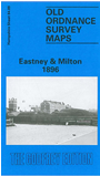
    This detailed map of the Eastney and Milton area of Portsmouth is double-sided for maximum coverage.

    The main map covers the area from Owen Street, Eastney, eastward to the Langstone Channel, and from Milton Farm southward to the coast. Features include Eastney Barracks, St Andrew's church, Coastguard Station, West Winner, rifle ranges, Port Royal Cottage, Highland Ward, St James church Milton, etc.

    On the reverse we include a portion of adjacent sheet 84.05 extending coverage northward to include Lunatic Asylum, Warren Lane area, Baffins, Great Salterns.

    The map links up with Hampshire Sheets 83.08 Central Portsmouth to the west and 83.12 Southsea to the south.

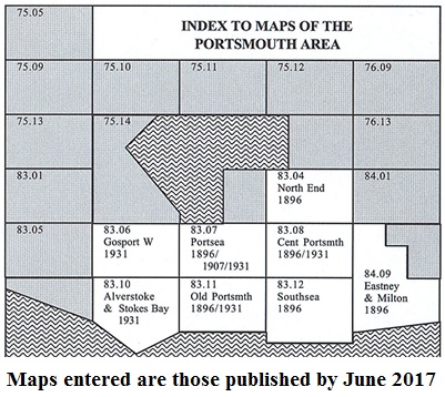
    You might find this Index Map useful.


  • Follow this link for a complete list for Portsmouth maps, or follow these links for the rest of Hampshire, or Isle of Wight.
  • You can order maps direct from our On-line Mapshop. For other information and prices, and other areas, go to The Index Page.
  • Maps in the Godfrey Edition are taken from the 25 inch to the mile map and reduced to about 15 inches to the mile. For a full list of maps for England, return to the England page.
    Alan Godfrey Maps, Prospect Business Park, Leadgate, Consett, Co Durham, DH8 7PW / sales@alangodfreymaps.co.uk / 17 January 2017