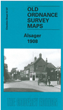
Cheshire Sheet 57.07 Alsager 1908 - published 2004; intro by Malcolm Nixon. ISBN.978-1-84151-610-3 
This detailed map covers the village of Alsager, a few miles east of Crewe. Most of the village is covered, and features
include the railway with station, Townhouse Farm, Holehouse Farm, Fanny's Croft, The Mere, Alsager Hall, Alsager Mill,
Christ Church, Milton House, Crewe Road, Foundry House, Alsager Arms Inn. On the reverse we include a directory of Alsager in 1896.
Follow this link for a complete list of our Cheshire maps.
You can order maps direct from our On-line Mapshop.
For other information and prices, and other areas, go to The Index Page.
Maps in the Godfrey Edition are taken from the 25 inch to the mile map and reduced to about 15 inches to the mile.
For a full list of maps for the North West, return to the North West page.
The Godfrey Edition / sales@alangodfreymaps.co.uk / 27 January 2018
 Here are the details of maps for Alsager: