Old Ordnance Survey Maps of Aberdeenshire

  • These detailed maps normally cover an area of about one and a half miles by one mile. Each map includes an introduction.
  • They are available through our On-line Mapshop

  • Here are the details of maps for Peterhead:

  • Aberdeenshire Sheet 23.07 Peterhead 1900 - published 1992; intro by Jim Buchan. ISBN.978-0-85054-513-5

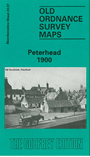
    This detailed map covers most of the port and town of Peterhead, with coverage stretching from the railway station eastward to the harbour.

    Features include Kirktown area, Springbank Mills, North and South Harbours, Keith Inch, Roanheads, Green Hill, Broad Street, town centre shown in detail with individual buildings neatly delineated, Poorhouse, fishcuring works, railway station (but at edge of map so not all approaches shown), Port Henry Harbour, etc.

    Adjacent sheet 23.03 is included as an inset. This shows the Buchanhaven area.


  • For other maps in Aberdeenshire visit our Aberdeenshire page.
  • For information on the local government changes to Aberdeenshire, Banffshire and Kincardineshire visit This Page.
  • Most maps in the Godfrey Edition are taken from the 25 inch to the mile map and reduced to about 15 inches to the mile. They cost just £ 3.00 each. For a full list of Scottish maps, return to the Scotland page.
  • You can order maps direct from our On-line Mapshop.
    Alan Godfrey Maps, Prospect Business Park, Leadgate, Consett, DH8 7PW. Tel 01207 583388
    The Godfrey Edition / sales@alangodfreymaps.co.uk / 14 March 2016