Old Ordnance Survey Maps of Mitcham


We have published more than 2,500 maps in our series of Old Ordnance Survey Map reprints, some 500 of them in the London area. The maps are highly detailed. They are taken from the OS 1:2,500 (or 25 inch) maps and reduced to about 15 inches to the mile. They show streets with individual houses, tram tracks, railway tracks and even signals, factories, wharves and such details as fountains and water troughs. They will provide hours of fascination for historians and genealogists. The maps are neatly folded and each includes a specially written introduction to the area. Maps can be purchased on our On-line Mapshop where further information about titles is given. For other information and Prices, see Index Page.


Here are details of the map for Mitcham:

  • Surrey Sheet 13.04 Mitcham 1910 - published 2012; intro by Richard Oliver. ISBN.978-1-84784-569-6

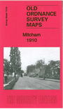
    This detailed map covers Lower Mitcham and the southern half of Upper Mitcham. Coverage stretches from the Upper Green and Eastfields southward to Mitcham Junction station (which straddles the southern margin).

    Features include railways with Mitcham station, St Mark's church, Upper Green, Mitcham House, tramways, Mitcham Hall, Imperial Works, River Wandle, Crown Mill, Wandle Grove, watercress beds, St Peter & St Paul's church, Cricket Green, Blue Houses etc. On the reverse we include a list of private residents from a 1903 directory.

    The map links up with Surrey sheet 13.03 Morden to the west and 13.08 Beddington Corner to the south.


    Follow this link for a complete list of our Surrey maps or our London Series.

    You can order maps direct from our On-line Mapshop. For other information and Prices, see Index Page.


    Maps in the Godfrey Edition are taken from the 25 inch to the mile map and reduced to about 15 inches to the mile. For a full list of maps for London, return to the London page.

    The Godfrey Edition / godfreyedition@btinternet.com / 14 Dec 2012