Old Ordnance Survey Maps of Auchterarder


We have published more than 2,000 maps in our series of Old Ordnance Survey Map reprints; this includes more than a hundred in Scotland, for most regions of the ountry. The maps are highly detailed. They are taken from the OS 1:2,500 (or 25 inch) maps and reduced to about 15 inches to the mile. Each covers an area of a mile and a half by a mile. They show streets with individual houses, tram tracks, railway tracks and even signals, factories, wharves and such details as fountains and water troughs. They will provide hours of fascination for historians and genealogists. The maps are neatly folded and each includes a specially written introduction to the area. Maps can be purchased on our On-line Mapshop where further information about titles is given. Or visit The Index Page for a full list to the series and details of Prices.


Here are the details of maps for Auchterarder:

  • Perthshire Sheet 118.02 Auchterarder 1900 - published 2007; introduction by Gilbert Bell

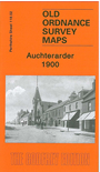
    This detailed map covers the small Perthshire town of Auchterarder. Most of the town centre is covered including Townhead, High Street, Feus, and coverage extends south to the railway and part of the station, eastward to Mill West Mill, north to Castle Mains, west to Lower and Upper Borelandpark. Features include St Kessog's church, Coll Earn, Ruthven Tower, Castleton, Castlebrae. A 1921 trade directory of the town is included on the reverse.


    Follow this link for a complete list of our Perthshire maps.

    You can order maps direct from our On-line Mapshop. For other information and prices, and other areas, go to The Index Page.


    Maps in the Godfrey Edition are taken from the 25 inch to the mile map and reduced to about 15 inches to the mile. For a full list of maps for Scotland, return to the Scotland page.

    The Godfrey Edition / godfreyedition@btinternet.com / 12 November 2007