
 Here is information about Sheet 354 & 355:
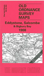
This Inch to the Mile map will perhaps appeal to those interested in cartographic curiosities as much as to historians. The main map, Sheet 355, covers the coastal area of Devon around Bigbury Bay, Bolt Tail and Holt Head. It includes Salcombe and Kingsbury, and coverage stretches from Ringmore and Bigbury SE to Prawle Point. On the reverse we include most of a very strange OS map, Sheet 354, which covered the Eddystone Rocks and nothing else. In his entertaining introduction Richard Oliver asks "why did the OS go to the trouble of preparing this sheet..." and then (perhaps ominously for the present publisher) remarks that "Sheet 354 cannot have been very saleable". But we all like curiosities and hopefully you will find Sheet 355, with its depiction of the area around Salcombe, worth our modest price.
It is not possible to list the many hamlets, farmsteads and other topographical features shown on these maps. However, you may find it useful if we list the towns and principal villages or church parishes that are included on this map. Links are given for those for which detailed large-scale maps are also available.
Index maps are available showing the areas covered by the Inch to the Mile maps. Go to This page
You can order maps direct from our On-line Mapshop. For a full list of Inch to the Mile maps go to the Inch to the Mile page, where you will also find details of prices. For information on the rest of the series, go to The Index Page.