
Old Ordnance Survey Inch to the Mile Maps
These maps normally cover an area of about 18 miles by 12 miles and are especially good at showing railways, roads and canals, and at giving
a broad view of a wider area. Each includes an introduction and a more detailed map of a small town or village.
They are available through our On-line Mapshop
 Here is information about Sheet 237:
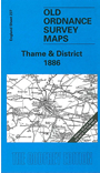
One Inch Sheet 237 Thame & District 1886 - published 2000; intro by Elizabeth Lockwood. ISBN.978-1-84151-200-6
This map, which is split between Buckinghamshire and Oxfordshire, covers the area from Cowley eastward to the west edge of Aylesbury, and from Chinnor northward to Ludgershall. The
towns on the map are Thame and Princes Risborough. Of the great estates the Rothschild's Waddesdon is the most celebrated on the map but Elizabeth
Lockwood also reminds us of Waterperry House, Horsendon House and Notley Abbey. Railways include the Chinnor branch, the long-closed Thame-Oxford route and the line from
Aylesbury to Quainton Road. At the west of the map villages lilke Cowley and Headington show the influence of nearby Oxford.
It is not possible to list the many hamlets, farmsteads and other topographical features shown on these maps. However, you may find it useful if we list the towns and
principal villages or church parishes that are included on this map:
Buckinghamshire: Aston Sandford, Bledlow, Boarstal, Brill, Chearsley, Chilton, Cuddington, Dinton, Dorton,
Haddenham, Hardwick, Horsendon, Ickford, Ilmer, Kingsey, Long Crendon, Lower Winchendon, Ludgershall, Monks Risborough,
Oakley, Princes Risborough, Saunderton, Shabbington, Stone, Towersey, Upper Winchendon, Waddesdon, Worminghall, Wotton Underwood.
Oxfordshire: Albury, Ambrosden, Beckley, Charlton on Otmoor, Chinnor, Cowley, Cuddesdon, Elsfield, Emington, Foresthill, Garsington, Great Haseley,
Great Milton, Headington, Holton, Horsepath, Merton, Noke, Oddington, Piddington, Sandford, Stanton St John, Sydenham,
Tetsworth, Thame, Toot Baldon, Waterperry, Waterstock, Weston on the Green, Wheatley, Wood Eaton.
Index maps are available showing the areas covered by the Inch to the Mile maps. Go to This page
You can order maps direct from our On-line Mapshop. For a full list of Inch to the Mile maps go to the Inch to the Mile page,
where you will also find details of prices. For information on the rest of the series, go to The Index Page.
Alan Godfrey Maps, Prospect Business Park, Leadgate, Consett, Co Durham, DH8 7PW / sales@alangodfreymaps.co.uk / 16 April 2011