
Old Ordnance Survey Inch to the Mile Maps
These maps normally cover an area of about 18 miles by 12 miles and are especially good at showing railways, roads and canals, and at giving
a broad view of a wider area. Each includes an introduction and a more detailed map of a small town or village.
They are available through our On-line Mapshop
 Here is information about Sheet 228:
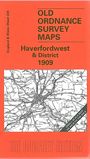
One Inch Sheet 228 Haverfordwest & District 1909 - published 2001; intro by Dillwyn Miles. ISBN.978-1-84151-295-2
This Inch to the Mile map covers the SE area of Pembrokeshire, around and to the east of Haverfordwest. Coverage stretches from Johnston eastward to Whitland, and from Rudbaxton southward to Pembroke Dock.
On the reverse is a large extract from Pembrokeshire Sheet 34.15, showing West Williamston and the quarries and limekilns near the Carew River.
It is not possible to list the many hamlets, farmsteads and other topographical features shown on these maps. However, you may find it useful if we list the towns and
principal villages or church parishes that are included on this map:
Pembrokeshire: Amroth, Begelly, Bletherston, Boulston, Burton, Camrose, Carew, Castelldwyran, Clarbeston, Cosheston, Crinow, Cyffic,
East Williamston, Egremont, Haroldston St Issells, Haverfordwest, Henllan Amgoed, Jeffreston, Johnston, Lampeter-Velfrey, Lawrenny, Llanddewi-Velfrey, Llanfallteg West, Llangwm,
Llanstadwell, Llawhaden, Loveston, Ludchurch, Marros, Martletwy, Minwear, Narberth, Neyland, Pembroke Dock, Redberth, Reynalton, Robeston Wathen, Rosemarket, Rudbaxton,
Saundersfoor, Upton, Uzmaston, West Williamston, Whitland, Yerbeston.
Index maps are available showing the areas covered by the Inch to the Mile maps. Go to This page
You can order maps direct from our On-line Mapshop. For a full list of Inch to the Mile maps go to the Inch to the Mile page,
where you will also find details of prices. For information on the rest of the series, go to The Index Page.
Alan Godfrey Maps, Prospect Business Park, Leadgate, Consett, Co Durham, DH8 7PW / sales@alangodfreymaps.co.uk / 16 April 2011