
Old Ordnance Survey Inch to the Mile Maps
These maps normally cover an area of about 18 miles by 12 miles and are especially good at showing railways, roads and canals, and at giving
a broad view of a wider area. Each includes an introduction and a more detailed map of a small town or village.
They are available through our On-line Mapshop
 Here is information about Sheet 217:
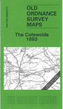
One Inch Sheet 217 The Cotswolds 1893 - published 2006; intro by Barrie Trinder. ISBN.978-1-84151-919-7
This Inch to the Mile map covers the heart of the Cotswolds, with coverage stretching from Broadway south to Bourton on the Water, and from Prestbury and the outskirts of Cheltenham eastward to Evenlode. Towns
on the map include Moreton-in-the-Marsh, Stow-on-the-Wold and Winchcomb. Most of the map is Gloucestershire although there are also fragments of Worcestershire, including detached portions.
On the reverse we include a map of the village of Bishop's Cleeve.
It is not possible to list the many hamlets, farmsteads and other topographical features shown on these maps. However, you may find it useful if we list the towns and
principal villages or church parishes that are included on this map. Links are given for those for which detailed large-scale maps are also available.
Gloucestershire: Alderton, Alstone, Ashton under Hill, Aston Somerville, Batsford, Beckford, Bishop's Cleeve, Bourton on the Hill, Bourton on the Water, Broadwell,
Buckland, Charlton Abbots, Charlton Kings, Childs Wickham, Church Iccomb, Condicote, Didbrook, Donnington, Farmcote, Gotherington, Great Washbourne, Gretton, Hailes, Little Washbourne, Longborough, Lower Lemington,
Lower Slaughter, Lower Swell, Maugersbury, Moreton in the Marsh, Oddington, Oxenton, Prestbury, Sevenhampton, Snowshill, Southam, Stanley Pontlarge, Stanton, Stanway,
Stow on the Wold, Toddington, Todenham, Upper Slaughter, Upper Swell, Westcote, Whittington, Winchcomb, Woodmancote, Woolstone, Wormington, Wyck Rissington.
Oxfordshire: Idbury.
Warwickshire: Stretton on the Foss.
Worcestershire: Blockley, Broadway, Conderton, Cutsdean, Evenlode, Overbury, Paxford, Sedgeberrow, Teddington.
Index maps are available showing the areas covered by the Inch to the Mile maps. Go to This page
You can order maps direct from our On-line Mapshop. For a full list of Inch to the Mile maps go to the Inch to the Mile page,
where you will also find details of prices. For information on the rest of the series, go to The Index Page.
Alan Godfrey Maps, Prospect Business Park, Leadgate, Consett, Co Durham, DH8 7PW / sales@alangodfreymaps.co.uk / 16 April 2011