
Old Ordnance Survey Inch to the Mile Maps
These maps normally cover an area of about 18 miles by 12 miles and are especially good at showing railways, roads and canals, and at giving
a broad view of a wider area. Each includes an introduction and a more detailed map of a small town or village.
They are available through our On-line Mapshop
 Here is information about Sheet 162:
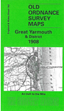
One Inch Sheet 162 Great Yarmouth & District 1908 - published 2001; intro by Robert Malster. ISBN.978-1-84151-524-3
This One Inch to the Mile map covers the eastern area of Norfolk around Acle, Loddon and Great Yarmouth, and includes Suffolk around Gorleston. Coverage stretches from Kirby Bedon eastward to the coast, and from
South Walsham southward to Flixton. Halvergate and its marshes are near the centre of the map. On the back is a large extract from Norfolk Sheet 77.15 and this shows the village of Reedham in detail; this includes the
church, village centre, railway junctions (but not station) including a stretch of abandoned line, and a short directory is also included.
It is not possible to list the many hamlets, farmsteads and other topographical features shown on these maps. However, you might find it useful if we here list the majority of the principal villages
and church parishes that are included on this map. Links are given for those for which detailed large-scale maps are also available.
Norfolk: Acle, Alpington, Ashby, Beighton, Bergh Apton, Billockby, Blofield, Bramerton, Brooke, Brundall, Burgh St Margaret, Caistor Yarmouth, Carleton St Peter, Castley, Chedgrave, Claxton, Filby,
Framingham Earl, Freethorpe, Great Plumstead, Great Yarmouth, Haddiscoe, Hale, Halvergate, Hardley, Hassingham, Heckingham, Hellington, Hemblington, Huckenham, Kirby Bedon, Langley, Limpenhoe, Lingwood,
Loddon, Mautby, Moulton, Mundham, Norton Subcourse, Postwick, Raveningham, Reedham, Rockland St Mary, Runham, Seething, Sisland, South Walsham, Southwood, Strumpshaw, Surlingham, Thrigby, Thurlton, Thwaite, Toft Monks, Tunstall,
Wickhampton, Witton, Yelverton.
Suffolk: Ashby, Belton, Blundeston, Bradwell, Burgh Castle, Corton, Flixton, Fritton, Gorleston, Gunton, Herringfleet, Hopton on Sea, Lound.
Index maps are available showing the areas covered by the Inch to the Mile maps. Go to This page
You can order maps direct from our On-line Mapshop. For a full list of Inch to the Mile maps go to the Inch to the Mile page,
where you will also find details of prices. For information on the rest of the series, go to The Index Page.
Alan Godfrey Maps, Prospect Business Park, Leadgate, Consett, Co Durham, DH8 7PW / sales@alangodfreymaps.co.uk / 16 April 2011