
Old Ordnance Survey Inch to the Mile Maps
These maps normally cover an area of about 18 miles by 12 miles and are especially good at showing railways, roads and canals, and at giving
a broad view of a wider area. Each includes an introduction and a more detailed map of a small town or village.
They are available through our On-line Mapshop
 Here is information about Sheet 160:
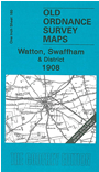
One Inch Sheet 160 Watton, Swaffham & District 1908 - published 2006; intro by Robert Malster. ISBN.978-1-84151-886-2
This One Inch to the Mile map covers an area of mid Norfolk, around Swaffham. Coverage stretches from Stoke Ferry eastward to Cranworth and the outskirts of East Dereham, and from Narborough southward toDidlington and Thompson.
Transport features include the Dereham & Lynn Branch, and Bury Thetford & Swaffham Branch railways. On the reverse we include a detailed map of the small
town of Watton, complete with directory.
It is not possible to list the many hamlets, farmsteads and other topographical features shown on these maps. However, you might find it useful if we here list the majority of the principal villages
and church parishes that are included on this map. Links are given for those for which detailed large-scale maps are also available.
Norfolk: Ashill, Barton Rendish, Beechamwell, Bodney, Boughton, Carbrooke, Caston, Cockley Cley, Cranworth, Didlington, East Bradenham,
Foulden, Gooderstone, Great Cressingham, Great Dunham, Great Fransham, Griston, Hilborough, Holme Hale, Houghton on the Hill, Langford, Little Cressingham, Little Dunham,
Little Fransham, Marham, Merton, Narborough, Necton, North Pickenham, Northwold, Ovington, Oxborough, Pentney, Saham Toney, Scarning, Shingham, Shipdham, South Acre,
South Pickenham, Sporle with Palgrave, Stoke Ferry, Stow Bedon, Swaffham, Thompson, Threxton, Watton, West Bradenham.
Index maps are available showing the areas covered by the Inch to the Mile maps. Go to This page
You can order maps direct from our On-line Mapshop. For a full list of Inch to the Mile maps go to the Inch to the Mile page,
where you will also find details of prices. For information on the rest of the series, go to The Index Page.
Alan Godfrey Maps, Prospect Business Park, Leadgate, Consett, Co Durham, DH8 7PW / sales@alangodfreymaps.co.uk / 16 April 2011