
Old Ordnance Survey Inch to the Mile Maps
These maps normally cover an area of about 18 miles by 12 miles and are especially good at showing railways, roads and canals, and at giving
a broad view of a wider area. Each includes an introduction and a more detailed map of a small town or village.
They are available through our On-line Mapshop
 Here is information about Sheet 124:
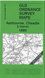
One Inch Sheet 124 Ashbourne, Cheadle & District 1895 - published 2008; intro by Barrie Trinder. ISBN.978-1-84784-164-3
This Inch to the Mile map is split between Staffordshire and Derbyshire, covering an area from Dilhorne eastward to Hollington, and from Grindon southward to Royleston. Features
include the Churnet Valley with its railway, and the Ashbourne Branch Railway. On the reverse we include a detailed map of the village of Rocester, with a directory.
It is not possible to list the many hamlets, farmsteads and other topographical features shown on these maps. However, you may find it useful if we list the towns and
principal villages or church parishes that are included on this map. Links are given for those for which detailed large-scale maps are also available.
Derbyshire: Alkmonton, Ashbourne, Atlow, Ballidon, Boyleston, Bradbourne, Bradley, Brassington, Carsington, Clifton, Edlaston & Wyaston,
Fenny Bentley, Great Cubley, Hognaston, Hollington, Hulland, Kniveton, Longford, Mapleton, Marston Montgomery, Norbury & Roston, Offcote & Underwood, Osleston & Thurvaston,
Osmaston, Parwich, Rodsley, Shirley, Snelston, Sturston, Thorpe, Tissington, Yeaveley.
Staffordshire: Alton, Bradley in the Moors, Caldon, Cheadle, Checkley, Cheddleton, Consall, Denstone, Dilhorne, Draycott in the Moors, Ellastone, Grindon,
Ilam, Ipstones, Kingsley, Mayfield, Okeover, Rocester, Stanton, Waterfall, Wootton.
Index maps are available showing the areas covered by the Inch to the Mile maps. Go to This page
You can order maps direct from our On-line Mapshop. For a full list of Inch to the Mile maps go to the Inch to the Mile page,
where you will also find details of prices. For information on the rest of the series, go to The Index Page.
Alan Godfrey Maps, Prospect Business Park, Leadgate, Consett, Co Durham, DH8 7PW / sales@alangodfreymaps.co.uk / 16 April 2011