
Old Ordnance Survey Inch to the Mile Maps
These maps normally cover an area of about 18 miles by 12 miles and are especially good at showing railways, roads and canals, and at giving
a broad view of a wider area. Each includes an introduction and a more detailed map of a small town or village.
They are available through our On-line Mapshop
 Here is information about Sheet 102:
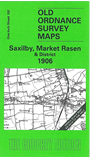
One Inch Sheet 102 Saxilby, Market Rasen & District 1906 - published 2004; intro by Nick Lyons. ISBN.978-1-84151-679-0
This Inch to the Mile map covers the area from Marton and Torksey eastward to Market Rasen, and from Bishop Norton southward to Reepham. Ermine Street runs north-south through
the centre of the map, which is of a low lying landscape, with many villages but only the one town, Market Rasen. On the reverse we include a detailed map of two of these small villages, Owmby and
Normanby by Spital - populations 307 and 237 respectively in 1901 - complete with directories for each.
It is not possible to list the many hamlets, farmsteads and other topographical features shown on these maps. However, you may find it useful if we list the towns and
principal villages or church parishes that are included on this map. Links are given for those for which detailed large-scale maps are also available.
Lincolnshire: Apley, Barlings, Bishop Norton, Brampton, Brattleby, Broadholme, Broxholme, Bullington, Burton, Buslingthorpe, Caenby, Coates, Cold Hanworth,
Corringham, Dunholme, East Firsby, Faldingworth, Fenton, Friesthorpe, Fulnetby, Gate Burton, Glentham, Grange de Lings, Hackthorn, Hardwick, Harpswell, Hemswell,
Ingham, Kettlethorpe, Kexby, Linwood, Lissington, Market Rasen, Nettleham, Newball, Newton by Toft, Normanby by Spital, Owmby, Rand, Reepham,
Riseholme, Saxby, Saxilby, Scampton, Scothern, Snarford, Snelland, South Carlton, Spridlington, Springthorpe, Stainton by Langworth, Stow, Sturton, Sudbrooke, Thorpe in the Fallows,
Toft next Newton, Torksey, Upton, Welton, West Firsby, West Rasen, Wickenby, Willingham.
Index maps are available showing the areas covered by the Inch to the Mile maps. Go to This page
You can order maps direct from our On-line Mapshop. For a full list of Inch to the Mile maps go to the Inch to the Mile page,
where you will also find details of prices. For information on the rest of the series, go to The Index Page.
Alan Godfrey Maps, Prospect Business Park, Leadgate, Consett, Co Durham, DH8 7PW / sales@alangodfreymaps.co.uk / 16 April 2011