
Old Ordnance Survey Inch to the Mile Maps
These maps normally cover an area of about 18 miles by 12 miles and are especially good at showing railways, roads and canals, and at giving
a broad view of a wider area. Each includes an introduction and a more detailed map of a small town or village.
They are available through our On-line Mapshop
 Here is information about Sheet 90:
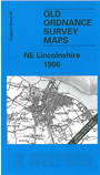
One Inch Sheet 90 NE Lincolnshire 1906 - published 2001; intro by Richard Oliver. ISBN.978-1-84151-250-1
This Inch to the Mile map covers the area of Lincolnshire from Great Limber eastward to Conisholme, and from Grimsby southward to Binbrook. Grimsby is much the largest place on the map; the only other town
is nearby Cleethorpes. A tiny portion of Yorkshire appears in the top right corner in the shape of Spurn Head. On the back we include a more detailed map of Brocklesby, including Brocklesby Hall, together with a directory for the village.
It is not possible to list the many hamlets, farmsteads and other topographical features shown on these maps. However, you may find it useful if we list the towns and
principal villages or church parishes that are included on this map. Links are given for those for which detailed large-scale maps are also available.
Lincolnshire: Ashby cum Fenby, Aylesby, Barnoldby le Beck, Beelsby, Binbrook, Bradley, Brigsley, Brocklesby, Caboutne, Cleethorpes, Conisholme, Covenham St Bartholomew, Covenham St Mary,
Cuxwold, East Ravendale, Fulstow, Grainthorpe, Gramsby, Great Coates, Great Limber, Grimsby, Hatcliffe, Healing, Holton le Clay,
Humberston, Keelby, Kirmond le Mire, Laceby, Little Coates, Ludborough, Marsh Chapel, North Coates, North Ormesby, North Thoresby, Riby, Rothwell, Scartho, Stainton le Vale, Stallingborough, Swallow,
Swinhope, Tetney, Thoresway, Thorganby, Utterby, Waithe, Waltham, Wold Newton, Yarburgh.
Index maps are available showing the areas covered by the Inch to the Mile maps. Go to This page
You can order maps direct from our On-line Mapshop. For a full list of Inch to the Mile maps go to the Inch to the Mile page,
where you will also find details of prices. For information on the rest of the series, go to The Index Page.
Alan Godfrey Maps, Prospect Business Park, Leadgate, Consett, Co Durham, DH8 7PW / sales@alangodfreymaps.co.uk / 16 April 2011