Old Ordnance Survey Maps of Merionethshire
These detailed maps normally cover an area of about one and a half miles by one mile. Each map includes an introduction.
They are available through our On-line Mapshop
 Here are the details of maps for Tywyn:
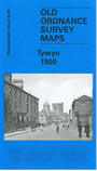
Merionethshire Sheet 46.09 Tywyn - published 2005; intro by Derrick Pratt. ISBN.978-1-84151-806-0 
The village of Tywyn - or Towyn - appears at the bottom of this map, with the area above being mainly fields, with a cemetary to the north
east of the village. Points of interest include St Cadvans Church, Gas Works, two schools and the Baptist Chapel. Other features include Kings Station
and just off College Green there is the Market Hall. On the reverse of the map there is a map to the north of Tywyn which shows the Promenade and Esguan Hall.
A good stretch of the Tal-y-llyn Railway is shown, including Pen-dre station. The map also includes an historical introduction by Derrick Pratt
Follow this link for a complete list of our Merionethshire Series maps.
You can order maps direct from our On-line Mapshop.
For other information and prices, and other areas, go to The Index Page.
Maps in the Godfrey Edition are taken from the 25 inch to the mile map and reduced to about 15 inches to the mile.
For a full list of maps for Wales, return to the Wales page.
The Godfrey Edition / sales@alangodfreymaps.co.uk / 31 March 2018