
 Here are the details of maps for March:

We have published two detailed maps for March; they link up with each other to provide good coverage of the town.
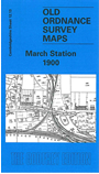
The March Station map covers the northern end of the town, around the station. Coverage extends west to Peas Hill, north to Flaggrass Hill Farm and Long Hill Farm. The railway is the dominant feature, and includes engine shed, goods shed, sidings and part of Station Road as far south as St John's church. Our author John Gough, a noted expert on railways, explains how March became so important a railway town. We also include GER timetable for the March-Wisbech-Kings Lynn line in 1915.
The March map, sheet 17.01, continues coverage south and covers the town itself. The Market Place is almost in the centre of the map and coverage extends west to West End, north to St John's church and the cemetery, south to The Caauseway and gasworks. Features include the River Nene, which flows across the map, Little London, High Street, Creek Road, Dartford Road, Cherryholt, St Peter's church, Nene Parade, brick works, Broad Street, New Park. We also include a commercial directory, listing the shops, tradesmen etc in 1912. Here the author is Trevor Bevis, author of several books on March and the Fens.