We have published more than 2,000 maps in our series of Old Ordnance Survey Map reprints; this includes more than a hundred in Scotland, with a growing range of maps around Glasgow. The maps are highly detailed. They are taken from the OS 1:2,500 (or 25 inch) maps and reduced to about 15 inches to the mile. Each covers an area of a mile and a half by a mile. They show streets with individual houses, tram tracks, railway tracks and even signals, factories, wharves and such details as fountains and water troughs. They will provide hours of fascination for historians and genealogists. The maps are neatly folded and each includes a specially written introduction to the area. Maps can be purchased on our On-line Mapshop where further information about titles is given. Or visit The Index Page for a full list to the series and details of Prices.
Here are the details of maps for Hamilton (N)
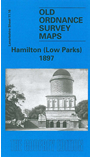
This detailed map covers the northern part of Hamilton, and is dominated by Hamilton Low Parks. In the SW corner are Clyde Colliery, Hamilton Poorhouse and Infantry Barracks. Other features include much of Hamilton Race Course, Great North Avenue, Back Muir Plantation, Barmichael Plantation, Mausoleum. On the reverse we include a bonus map: a six inch to the mile map of the area in 1859, and this attractive early map covers a wider area, including Bothwell, Bothwellhaugh and Kirkfield.
You might find this index map useful. The map links up with Sheets 11.15 Stonefield to the west, 12.13 Motherwell to the east, and 17.04 Hamilton to the south.
Follow this link for a complete list of our Lanarkshire maps.
You can order maps direct from our On-line Mapshop. For other information and prices, and other areas, go to The Index Page.
Maps in the Godfrey Edition are taken from the 25 inch to the mile map and reduced to about 15 inches to the mile. For a full list of maps for Scotland, return to the Scotland page.
The Godfrey Edition / godfreyedition@btinternet.com / 31 December 2006