These maps are taken from the famous OS "Inch to the Mile" Maps. Though obviously far less detailed than the large scale maps for which we are perhaps better known, they provide an invaluable overview of a wider area, typically 18 miles across by 12 miles down. For transport historians they are invaluable for showing old railways, while all historians need them for their close depiction of topography, normally including parish boundaries. These maps also mean that we can offer historical coverage for small villages where a large scale map would not be commercially viable.
This group of Irish reprints was begun in the 1980s with some titles in Fermanagh and Tyrone. We now intend to publish the whole of Northern Ireland in this series, in addition to those for England and Wales. The maps include historical notes and most also include a large scale map of a small town or village in the area.
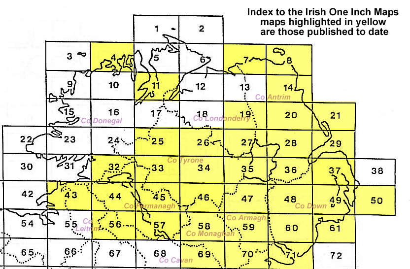
Here is information about Sheet 48:
This Inch to the Mile map covers an area of central County Down with coverage stretching from Lawrencetown eastward to Ballynahinch, and from Waringstown southward to Katesbridge. It includes the towns of Banbridge and Dromore, the three railways converging on Banbridge, Monahoora, Slievenisky, Slieve Croob, the source of the Lagan, the western side of Ballynhainch, Deehommed Mountain, mills and bleach works, etc. On the reverse we include a detailed map of the village of Waringstown.
It is not possible to list the many hamlets, farmsteads and other topographical features shown on these maps. However, you may find it useful if we list the towns and principal villages or church parishes that are included on this map. Links are given for those for which detailed large-scale maps are also available.
An index map is available showing the areas covered by the Inch to the Mile maps. Go to This Index Map.
For a full list of maps for Ireland go to the Ireland page.
You can order maps direct from our On-line Mapshop. For other information and prices, and other areas, go to The Index Page.