Old Ordnance Survey Maps of Kingston upon Hull
>This is our coverage of the City of Hull. The county of Humberside was formed in 1974 to cover areas on both sides of the Humber. On the Yorkshire side this included the County Borough of
Kingston upon Hull, Beverley Borough, Bridlington Borough, Goole Borough, Hedon Borough, Driffield Urban District, Haltemprice Urban District, Hornsea Urban District, Withernsea Urban District,
Beverley Rural District, Driffield Rural District, Goole Rural District, Holderness Rural District, Howden Rural District, and Pocklington Rural District. The principal districts on the Lincolnshire side were the
County Borough of Grimsby, Cleethorpes Borough and Scunthorpe Borough. The county was divided into 9 districts, 5 of them on the Yorkshire side: these were Beverley, Boothferry, Holderness, Kingston upon Hull,
and North Wolds (later renamed East Yorkshire).
In 1996 Humberside was abolished as a county and the Yorkshire or 'North Humberside' part was divided into two unitary authorities, East Riding of Yorkshire, and Kingston upon Hull. Maps in the
City of Kingston upon Hull are listed here.
226.14 Hull (NW) 1909 - published 2009; intro by Susan Neave
226.15 Hull (NE) 1908 - published 2007; intro by Susan Neave
240.02a Hull (West) 1890 - published 2011; intro by Susan Neave  240.02b Hull (West) 1908 - published 2006; intro by Alan Godfrey
240.02c Hull (West) 1928 - published 1987; intro by Geoffrey Oxley
240.03a Hull (East) 1890 - published 2011; intro by Susan Neave
240.03b Hull (East) 1908 - published 2007; intro by Susan Neave
240.03c Hull (East) 1928 - published 1987; intro by Arthur G Credland
240.04 Hull (Alexandra Dock) 1908 - published 2007; intro by Alan Godfrey
240.06a Hull (Hessle Road) 1890 - published 2012; intro by Susan Neave
240.06b Hull (Hessle Road) 1928 - published 1987; intro by Arthur G Credland
240.02b Hull (West) 1908 - published 2006; intro by Alan Godfrey
240.02c Hull (West) 1928 - published 1987; intro by Geoffrey Oxley
240.03a Hull (East) 1890 - published 2011; intro by Susan Neave
240.03b Hull (East) 1908 - published 2007; intro by Susan Neave
240.03c Hull (East) 1928 - published 1987; intro by Arthur G Credland
240.04 Hull (Alexandra Dock) 1908 - published 2007; intro by Alan Godfrey
240.06a Hull (Hessle Road) 1890 - published 2012; intro by Susan Neave
240.06b Hull (Hessle Road) 1928 - published 1987; intro by Arthur G Credland
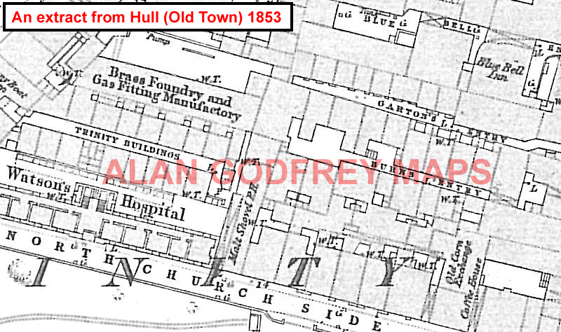
We have also published some very early large scale plans, showing parts of Hull in even greater detail. These are taken from the 'Five foot' plans and reduced to a scale of a Yard to the Mile. A sample extract is given here.

07 Hull Prospect Street 1853 - published 2009; intro by Susan Neave
08 Hull Queen's Dock 1853 - published 2009; intro by Susan Neave
11 Hull Railway Dock & Paragon Stn 1853 - published 2008; intro by Susan Neave
12 Hull Old Town 1853 - published 1988; intro by Arthur G Credland
The area is also covered in our Inch to the Mile series. Here is the principal sheet for Hull:
Sheet 80 Hull & North Lincolnshire 1895 - published 2000; intro by Nick Lyons. Includes a map of New Holland
For further details of our One Inch Maps, visit the One Inch page.
 Most maps in the Godfrey Edition are taken from the 25 inch to the mile map and reduced to about 15 inches to the mile.
For a full list of Yorkshire maps, return to the Yorkshire page
You can order maps direct from our On-line Mapshop.
Most maps in the Godfrey Edition are taken from the 25 inch to the mile map and reduced to about 15 inches to the mile.
For a full list of Yorkshire maps, return to the Yorkshire page
You can order maps direct from our On-line Mapshop.
Alan Godfrey Maps, Prospect Business Park, Leadgate, Consett, DH8 7PW. Tel 01207 583388
The Godfrey Edition / sales@alangodfreymaps.co.uk / 23 Sept 2016