Old Ordnance Survey Maps of Leith (N)


We have published more than 2,400 maps in our series of Old Ordnance Survey Map reprints; this includes more than 150 in Scotland, with a good range of maps around Edinburgh. The maps are highly detailed. They are taken from the OS 1:2,500 (or 25 inch) maps and reduced to about 15 inches to the mile. Each covers an area of a mile and a half by a mile. They show streets with individual houses, tram tracks, railway tracks and even signals, factories, wharves and such details as fountains and water troughs. They will provide hours of fascination for historians and genealogists. The maps are neatly folded and each includes a specially written introduction to the area. Maps can be purchased on our On-line Mapshop where further information about titles is given. Or visit The Index Page for a full list to the series and details of Prices.


Here are the details of maps for Leith (N):
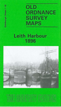
  • Edinburghshire Sheet 1.16 Leith Harbour 1896 - published 1984; introduction by Barbara Morris & R.J.Morris

    This detailed map covers north Leith, including most of the harbour. Coverage stretches from Summerside Street eastward to Salamander Street, and from Charlotte Street northward to the Black Rocks.

    Features include Edinburgh Dock, Albert Dock, Victoria Dock, West and East Old Docks, Outer Harbour, Inner Harbour, Martello Tower, timber yards, Leith Fort, Water of Leith, Custom House, South Leith Goods Station, CR Leith station, NBR railway with stations, sidings, tramways, graving dock, North Leith Poorhouse etc. On the reverse we include street directory entries for Bernard Street, Commercial Street, Constitution Street, Shore, Couper Street.

    The map links up with Edinburgh Sheets 1.15 Newhaven to the west and 3.04 Leith Walk to the south..


    You might find this index map useful.


    Follow this link for a complete list of our Edinburgh maps.

    You can order maps direct from our On-line Mapshop. For other information and prices, and other areas, go to The Index Page.


    Maps in the Godfrey Edition are taken from the 25 inch to the mile map and reduced to about 15 inches to the mile. For a full list of maps for Scotland, return to the Scotland page.

    The Godfrey Edition / godfreyedition@btinternet.com / 9 Dec 2010