Old Ordnance Survey Maps of Dunbartonshire

  • These detailed maps normally cover an area of about one and a half miles by one mile. Each map includes an introduction.
  • They are available through our On-line Mapshop

  • Here are the details of maps for Bearsden:

  • Dumbartonshire Sheet 23.16 Bearsden 1896 - published 2016; intro by Gilbert Bell. ISBN.978-1-84784-952-6

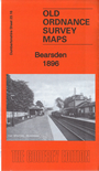
    This detailed map covers Bearsden, just NW of Glasgow, and is double-sided for maximum coverage.

    Features include NBR railway with Bearsden station, village with individual buildings neatly shown, Buchanan Retreat, East Chapelton Reformatory, Whitehill Woods, Canniesburn, St Germains Loch, Killermont Cottage, line of Antonine Wall, Schaw Convalescent Home, Hillfoot, Kilmardinny House and Loch, Lower Kilmardinny, Burnbrae Dye Works, Burnbrae House etc


  • Follow this link for a complete list of our Dunbartonshire maps.
  • You can order maps direct from our On-line Mapshop. For other information and prices, and other areas, go to The Index Page.
  • Maps in the Godfrey Edition are taken from the 25 inch to the mile map and reduced to about 15 inches to the mile. For a full list of maps for Scotland, return to the Scotland page.
    The Godfrey Edition / sales@alangodfreymaps.co.uk / 11 November 2016