Old Ordnance Survey Maps of East Sussex

  • These detailed maps normally cover an area of about one and a half miles by one mile. Each map includes an introduction.
  • They are available through our On-line Mapshop

  • Here are the details of maps for Battle:

  • Sussex Sheet 57.04 Battle 1937 - published Dec 2005; intro by Tony Painter. ISBN.978-1-84151-846-6

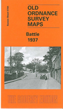
    This detailed map of Battle is double-sided to provide maximum coverage. The main map covers the east of the town, coverage stretching from High Street eastward to an area of woodland that includes Great Wood, Great Branshill Wood and Kiln Wood. Features include St Martin's Abbey, railway station, St Mary's church, cemetery, Battle Hill, Telham Court, Blackfriars, Starr's Green, and part of the site of the Battle of Hastings. On the reverse we include part of sheet 57.03, which extends coverage westward along North Trade Road as far as the Poor Law Institution.

    You might find this index map useful.


  • Follow these links for complete lists of our West Sussex and East Sussex maps.
  • You can order maps direct from our On-line Mapshop. For other information and prices, and other areas, go to The Index Page.
  • Most maps in the Godfrey Edition are taken from the 25 inch to the mile map and reduced to about 15 inches to the mile. For a full list of maps for England, return to the England page.
    The Godfrey Edition / sales@alangodfreymaps.co.uk / 1 December 2016