Old Ordnance Survey Maps of Worcestershire

  • These detailed maps normally cover an area of about one and a half miles by one mile. Each map includes an introduction.
  • They are available through our On-line Mapshop

  • Here are the details of maps for Bewdley:

  • Worcestershire Sheet 14.01 Bewdley 196 - published 2004; intro by Barrie Trinder. ISBN.978-1-84151-638-7

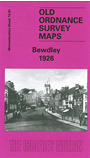
    This detailed map covers the town of Bewdley; coverage extends eastward to Sandbourne House, westward to Tanner's Hill. Wribbenhall, on the NE bank of the Severn, is also included.

    Features include GWR railway with Bewdley station, River Severn, All Saints church Wribbenhall, St Anne's church, Sandbourne House, Winterdyne, Kateshill House, Manor House, Tickenhill, Snuffmill Dingle, many orchards, Bark Hill area, Patchett's Hill, etc. On the reverse we include the commercial entry from an 1896 directory, plus a section from the GWR Severn Valley Branch timetable for 1906.


  • You can order maps direct from our On-line Mapshop. For other information, a full catalogue and Prices, see Index Page.
  • Maps in the Godfrey Edition are taken from the 25 inch to the mile map and reduced to about 15 inches to the mile. For a full list of maps for the area, return to the Worcestershire page or West Midlands page.
    The Godfrey Edition / sales@alangodfreymaps.co.uk / 7 November 2016