
 Here are the details of maps for Westminster:

We have published three versions of this map, showing how the area developed across the years. The maps each cover the same major area of central London, stretching from Cadogan Square eastward to Westminster Abbey, and from St James's Square southward to Victoria station. Buckingham Palace is in the centre of the map.
Other features include the west side of Whitehall, including Downing Street; Westminster Abbey (though Parliament is on the Waterloo map); Victoria Street, Smith Square, Westminster Cathedral, Victoria station (but not its approaches); Belgravia, with Eaton Square, Belgrave Square, Cadogan Place, Grosvenor Place; Hyde Park Corner, Knightsbridge, Lowndes Square, Apsley House, the SE corner of Hyde Park; part of Piccadilly and Mayfair including Curzon Street, The Ritz, Devonshire House, Dorchester House; Pall Mall, St James's Palace, Carlton Gardens, Nelson's Monument (top right corner of map), Admiralty Arch; while the greenery of Green Park and St James's Park covers much of the central area of the map. There are street directory extracts and the 1916 map also has a 1916 Court Guide, listing the Royal Family and Chief Officers of State.
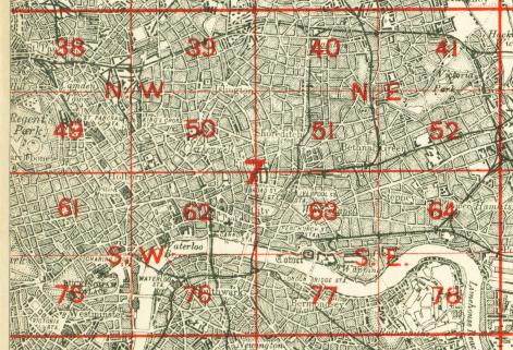
The map links up with London Sheets 61 West End to the north, 74 Kensington to the west, 76 Waterloo to the east, 88 Pimlico to the south.
 Follow this link for a complete list of our London maps .