Old Ordnance Survey Maps of Dorset

  • These detailed maps normally cover an area of about one and a half miles by one mile. Each map includes an introduction.
  • They are available through our On-line Mapshop

  • Here are the details of maps for Shaftesbury:

  • Dorset Sheet 4.14 Shaftesbury 1900 - published 1990; intro by Alan Godfrey. ISBN.978-0-85054-314-8

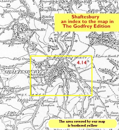
    This detailed map covers the hill-top town of Shaftesbury. Features include the town centre, Holy Trinity church, High Street, St James, Butts Knap, Hawksdean Lane, St Rumbold's church, workhouse, Breach Common, Alcester, Castle Hill, Gold Hill, Park Walk, Payne's Place. Also Bimport, which features in Thomas Hardy's Jude the Obscure, where Shaftesbury is referred to as Shaston. On the north side of town the map covers Enmore Green and Long Cross.

    You might find this index map useful.


  • Follow this link for a complete list of our Dorset Series maps.
  • You can order maps direct from our On-line Mapshop. For other information and prices, and other areas, go to The Index Page.
  • Maps in the Godfrey Edition are taken from the 25 inch to the mile map and reduced to about 15 inches to the mile. For a full list of maps for the South West, return to the South West page.
    The Godfrey Edition / sales@alangodfreymaps.co.uk / 12 January 2018