
Old Ordnance Survey Inch to the Mile Maps
These maps normally cover an area of about 18 miles by 12 miles and are especially good at showing railways, roads and canals, and at giving
a broad view of a wider area. Each includes an introduction and a more detailed map of a small town or village.
They are available through our On-line Mapshop
 Here is information about Sheet 250:
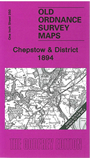
One Inch Sheet 250 Chepstow & District 1894 - published 2008; intro by Derrick Pratt. ISBN.978-1-84784-116-2
This Inch to the Mile map covers the area around Chepstow and includes parts of both Monmouthshire and Gloucestershire. This map completes our coverage of Wales in the
Inch to the Mile Series. Coverage stretches from Usk (in the top left corner) eastward to
Thornbury and southward to Redwick and Almonsbury. The Severn Tunnel area is included together with a good stretch of the Severn Estuary. On the reverse we include a map of Beachley in c.1920,
showing the Shipworkers Camp and part of the Shipyard.
It is not possible to list the many hamlets, farmsteads and other topographical features shown on these maps. However, you may find it useful if we list the towns and
principal villages or church parishes that are included on this map. Links are given for those for which detailed large-scale maps are also available.
Gloucestershire: Almondsbury, Alveston, Alvington, Aust, Beachley, Hill, Lancaut, Littleton upon Severn, Northwick, Oldbury upon Severn, Olveston, Redwick, Rockhampton, Thornbury,
Tidenham, Woolaston.
Monmouthshire: Bishton, Caerwent, Caldicot, Chapel Hill, Chepstow, Dinham, Ifton, Itton, Keineys-Inferior, Kilgwrrwg, Llanbadock, Llangeview, Llangibby, Llangstone, Llangwm, Llangwm-isaf,
Llanowel, Llanmartin, Llantrissent, Llanvaches, Llanvair Driscoed, Llanvihangel near Roggiett, Llanwern, Major, Mathern, Mounton, Newchurch, Penhow, Penterry, Portskewet, Redwick, Roggiett, Shire-Newton, St Arvan,
St Arvans Grange, St Brides Netherwent, Tintern Parva, Tredunnock, Undy, Usk, Whitson, Wilcrick, Wolves-Newton.
Index maps are available showing the areas covered by the Inch to the Mile maps. Go to This page
You can order maps direct from our On-line Mapshop. For a full list of Inch to the Mile maps go to the Inch to the Mile page,
where you will also find details of prices. For information on the rest of the series, go to The Index Page.
Alan Godfrey Maps, Prospect Business Park, Leadgate, Consett, Co Durham, DH8 7PW / sales@alangodfreymaps.co.uk / 16 April 2011