Inch to the Mile Maps of Ireland

  • These Old Ordnance Survey Maps normally cover an area of about 18 miles by 12 miles and are especially good at showing railways, roads and canals, and at giving a broad view of a wider area. Each includes an introduction and a more detailed map of a small town or village. They are available through our On-line Mapshop

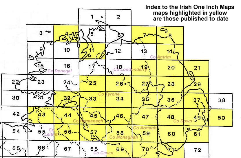
  • Here is information about Sheet 71:

  • Ireland Sheet 71 Carlingford Lough 1900 - published 2010; intro by Alan Godfrey. ISBN.978-1-84784-429-3

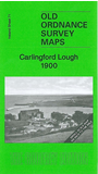
    This Inch to the Mile map covers the area around Carlingford Lough and the Cooley Peninsula, with areas of both County Down and County Louth.

    Coverage extends from Warrenpoint southward to the Cooley Peninsula and Dundalk Bay, and from Ravensdale and Ballymascanlan eastward to Kilkeel. Features include the towns of Carlingford, Kilkeel and Warrenpoint, the port of Greenore, and the resort of Rostrevor. Other features include Greencastle, Mourne Park, Carnavaddy, Carlingford Mountain etc. On the reverse we include a detailed map of Carlingford itself, showing the town including harbour, railway station, castles, City Wall, St Michael's RC church, Ghan House, Abbey etc.


    It is not possible to list the many hamlets, farmsteads and other topographical features shown on these maps. However, you may find it useful if we list the towns and principal villages or church parishes that are included on this map. Links are given for those for which detailed large-scale maps are also available.

  • Co Down: Ballymartin, Ballyneddan, Greencastle, Kilkeel, Rostrevor, Warrenpoint.
  • Co Louth: Ballymascanlan, Carlingford, Greenore, Ravensdale, White's Town.
  • An index map is available showing the areas covered by the Inch to the Mile maps. Go to This Index Map.
  • For a full list of maps for One Inch maps for Ireland go to the Ireland Inch to the Mile page; or for other maps of Ireland visit the Ireland page.
  • You can order maps direct from our On-line Mapshop. For other information and prices, and other areas, go to The Index Page.
    Alan Godfrey Maps, Prospect Business Park, Leadgate, Consett, Co Durham, DH8 7PW / sales@alangodfreymaps.co.uk / 16 January 2018