
 Here are the details of maps for Gillingham:

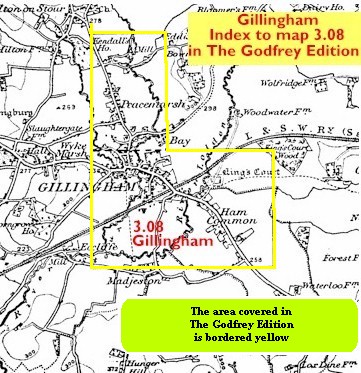
This detailed map covers the town of Gillingham, which stands at the north of the Blackmore Vale. The map is double-sided to provide maximum coverage. The main map covers the area from St Mary's church and the town centre southward to Madjeston Bridge and eastward to Ham Common, Higher Ham Farm and the site of King's Court Palace. Features include the station, River Lodden, cattle market, bacon and cheese factories, High Street, Wyke Street, Town Mills. On the reverse is a large section of sheet 3.04 extending coverage northward to Bay Lane, Lodbourn Farm, Peacemarsh and along the Shreen Water to Colesbrook. Purns Mills, about a mile north of the town centre, are at the top of the map.
You might find this index map useful.