We have published more than 1,800 maps in our series of Old Ordnance Survey Map reprints, including a group in Dorset. The maps are highly detailed. They are taken from the OS 1:2,500 (or 25 inch) maps and reduced to about 15 inches to the mile. Each covers an area of a mile and a half by a mile. They show streets with individual houses, tram tracks, railway tracks and even signals, factories, wharves and such details as fountains and water troughs. They will provide hours of fascination for historians and genealogists. The maps are neatly folded and each includes a specially written introduction to the area. Maps can be purchased on our On-line Mapshop where further information about titles is given. Or visit The Index Page for a full list to the series and details of Prices.
Here are the details of maps for Wimborne Minster:
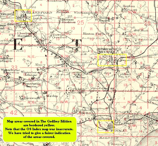
This detailed map is double-sided to provide maximum coverage. The main map covers the area from Little Pamphill eastward to the town centre, and beyond that to St Johns Hill and Avenue Road; also from Walford Bridge southward to Poole Road. Features include the Minster church, Julian Brewery, East Brook, Town Brewery, Westfield, West Borough, Wimborne & Cranborne Workhouse, East Street, cemetery, Rowlands, Knobcrook, Walford Bridge, Stone Lane, St Margaret's Almshouses, Julian's Bridge, River Stour, Stone Park, Farrs, Netherwood Mead, Gillingham's Almshouses. On reverse is more than half of adjacent map 35.05 which covers railway station, Cattle Market, Leigh, Green Close Dairy, Leigh Common, Leigh Vinery.
You might find this index map useful.
Follow this link for a complete list of our Dorset Series maps.
You can order maps direct from our On-line Mapshop. For other information and prices, and other areas, go to The Index Page.
Maps in the Godfrey Edition are taken from the 25 inch to the mile map and reduced to about 15 inches to the mile. For a full list of maps for the South West, return to the South West page.
The Godfrey Edition / godfreyedition@btinternet.com / 24 October 2005