

 Here are the details of maps for the Waterloo area:

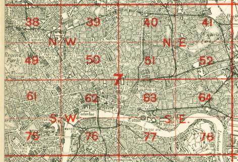
We have published three versions of this map, showing how the area developed across the years. The maps each cover the same area, which includes the Waterloo area, much of Lambeth and Southwark, and the area we now know as the South Bank. Coverage stretches from Waterloo Bridge eastward to Borough High Street, and from Waterloo Bridge southward to Lambeth Palace and Elephant & Castle. A small stretch of Westminster is also here, including the Houses of Parliament and New Scotland Yard. Other features on these very busy maps include Lambeth Bridge, Hungerford Bridge; Charing Cross, Waterloo, Necropolis and Elephant & Castle stations, with many junctions and sidings; St Thomas's Hospital, Bethlem Hospital, Southwark %RC Cathedral, Metropolitan Tabernacle, St George's Circus, Anchor Brewery, and countless factories, wharves, streets, prisons etc.
The map links up with London Sheets 62 Holborn to the north, 75 Westminster to the west, 77 Bermondsey to the east, and 89 Kennington to the south.
 Follow this link for a complete list of our London maps .