Old Ordnance Survey Maps of Surrey

  • These detailed maps normally cover an area of about one and a half miles by one mile. Each map includes an introduction.
  • They are available through our On-line Mapshop

  • Here are the details of the map for Epsom:

  • Surrey Sheet 19.05 Epsom 1912 - published 2012; intro by Richard Oliver. ISBN.978-1-84784-620-4

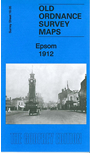
    This detailed map covers much of Epsom, from the stations southward to Durdans and Woodcote House, and from Stamford Green eastward to Alexandra Road.

    Features include town centre with individual buildings neatly shown, High Street, Clock Tower, LSWR and LBSCR stations, Woodcote Hall, Woodcote House, Upland House, St Martin's church, Pikeshill, Down Hall,Workhouse, Union Hall, Hookfield, Clayhill Green, Westhill House etc. On the reverse we include a list of private residents from a 1903 directory.


  • Follow this link for a complete list of our Surrey maps, here for Croydon, or here for the London Boroughs.
  • You can order maps direct from our On-line Mapshop. For other information and Prices, see Index Page.
  • Most maps in the Godfrey Edition are taken from the 25 inch to the mile map and reduced to about 15 inches to the mile.
    The Godfrey Edition / sales@alangodfreymaps.co.uk / 12 January 2018