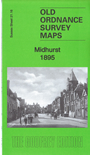
Sussex Sheet 21.16 Midhurst 1895 - published 2017; intro by Richard Oliver. ISBN.978-1-78721-089-9 
This detailed map gives good coverage of Midhurst.
Features include town centre with individual buildings neatly shown, LSWR and LBSCR stations and railway, Guillards Oak, Beggars Corner,
St Mary's church, Costers Mill, St Ann's Hill, Cowdray ruins, North Mill, Taylor's Farm, Town Hall, Grammar School, Balls Barn etc. We include extracts from
a 1905 directory on the reverse.
Follow these links for complete lists of our West Sussex and East Sussex maps.
You can order maps direct from our On-line Mapshop.
For other information and prices, and other areas, go to The Index Page.
Most maps in the Godfrey Edition are taken from the 25 inch to the mile map and reduced to about 15 inches to the mile.
For a full list of maps for England, return to the England page.
The Godfrey Edition / sales@alangodfreymaps.co.uk / 25 Sept 2017
 Here are the details of the maps for Midhurst: