We have published more than 1,800 maps in our series of Old Ordnance Survey Map reprints, including a group in Dorset. The maps are highly detailed. They are taken from the OS 1:2,500 (or 25 inch) maps and reduced to about 15 inches to the mile. Each covers an area of a mile and a half by a mile. They show streets with individual houses, tram tracks, railway tracks and even signals, factories, wharves and such details as fountains and water troughs. They will provide hours of fascination for historians and genealogists. The maps are neatly folded and each includes a specially written introduction to the area. Maps can be purchased on our On-line Mapshop where further information about titles is given. Or visit The Index Page for a full list to the series and details of Prices.
Here are the details of maps for Sherborne:
This detailed map covers the attractive north Dorset town of Sherborne. The town centre is covered, and coverage extends eastward to Sherborne Castle. Other features include the Abbey Church, King's School, station, workhouse, Castleton, remains of old castle, the 16th century Castle, Cheap Street, The Parade, Silk Mill, Newland, Green Hill, part of Nether Coombe, Digby Hotel. We include a contemporary directory on the reverse.
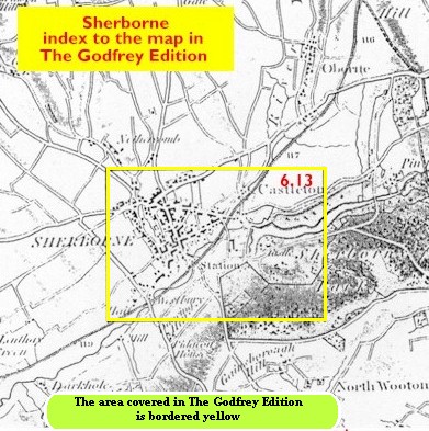
You might find this index map useful.
Follow this link for a complete list of our Dorset Series maps.
You can order maps direct from our On-line Mapshop. For other information and prices, and other areas, go to The Index Page.
Maps in the Godfrey Edition are taken from the 25 inch to the mile map and reduced to about 15 inches to the mile. For a full list of maps for the South West, return to the South West page.
The Godfrey Edition / godfreyedition@btinternet.com / 24 October 2005