We have published more than 1,800 maps in our series of Old Ordnance Survey Map reprints, some 300 of them in the London area. The maps are highly detailed. They are taken from the OS 1:2,500 (or 25 inch) maps and reduced to about 15 inches to the mile. They show streets with individual houses, tram tracks, railway tracks and even signals, factories, wharves and such details as fountains and water troughs. They will provide hours of fascination for historians and genealogists. The maps are neatly folded and each includes a specially written introduction to the area. Maps can be purchased on our On-line Mapshop where further information about titles is given.
For a full list of maps for London, go to the London page. Or go to The Index Page for a guide to our whole series and Prices.
Here are the details of maps for Putney Vale:
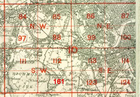
At present we have just one map for this area of Putney (but see sheet 113 for Putney itself). It covers the largely undeveloped area south of Putney and Roehampton, stretching from Richmond Park and White Lodge eastward to Putney Heath, from Manresa House and Holy Trinity church southward to Putney Vale and Robin Hood Gate. Most of the map is therefore parkland or common, including a fragment of Wimbledon Common with windmill, and the eastern area of Richmond Park. The area of villas called Roehampton Park is included and other features include Putney Vale cemetery, Kingston Road, Bessborough Road.
The map links up with Sheets 112 Roehampton to the north, 123 Southfields to the east.
Follow this link for a complete list of our London maps.
You can order maps direct from our On-line Mapshop. For other information and prices, go to The Index Page.
Maps in the Godfrey Edition are taken from the 25 inch to the mile map and reduced to about 15 inches to the mile. For a full list of maps for London, return to the London page
The Godfrey Edition / godfreyedition@btinternet.com / 27 Nov 2005