Old Ordnance Survey Maps of New Eltham


We have published more than 1,800 maps in our series of Old Ordnance Survey Map reprints, including a group in Kent. The maps are highly detailed. They are taken from the OS 1:2,500 (or 25 inch) maps and reduced to about 15 inches to the mile. Each covers an area of a mile and a half by a mile. They show streets with individual houses, tram tracks, railway tracks and even signals, factories, wharves and such details as fountains and water troughs. They will provide hours of fascination for historians and genealogists. The maps are neatly folded and each includes a specially written introduction to the area. Maps can be purchased on our On-line Mapshop where further information about titles is given. Or visit The Index Page for a full list to the series and details of Prices.


Here are the details of maps for New Eltham:

  • Kent Sheet 8.06 New Eltham 1895 - published 2001; introduction by Joh Kennett

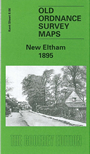
    This detailed map is centred on the hamlet of New Eltham, formerly known as Pope Street, a community that developed after the arrival of the railway. The station is in the centre of the map, where Southwood Road and Footscray Road cross. Green Lane runs north-south to the west, with the small community of South End at the top. To the east is a cluster of nurseries, near Blackboy Wood. When the railway arrived in the 1860s the area did not have enough population for a station but Pope Street (later New Etham) station opened in 1878. Even in 1895 this remains a fairly rural scene. On the reverse we include extracts from Walsham Bros New Eltham Directory.

    An index map showing the areas covered by this and adjacent Kent maps is available here. The map links up with Kent Sheets 8.05 Mottingham to the west, 8.07 Lamorbey to the east and 8.10 Chislehurst North to the south.


    Follow this link for a complete list of our Kent Series maps.

    You can order maps direct from our On-line Mapshop. For other information and prices, and other areas, go to The Index Page.


    Maps in the Godfrey Edition are taken from the 25 inch to the mile map and reduced to about 15 inches to the mile. For a full list of maps for Kent, return to the South East page

    The Godfrey Edition / godfreyedition@btinternet.com / 26 October 2005