
 Here are the details of maps for Maidstone:

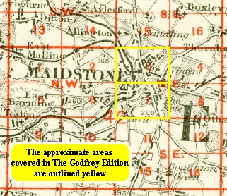
We have published two maps for Maidstone, North and South, which link up to provide good coverage of the town. Each covers an area of a mile by a mile and a half. They are so detailed that individual houses are shown.
The Maidstone North map covers the area from Summerfield Terrace eastward to Gallows Wood and Huntsman Farm, and from Earl Street and Holy Trinity church northward to Medway Paper Mill and Thornhills. The County Gaol is a major feature by default, for it is left blank for security reasons. Depicted features include Perseverance Foundry, Sittingbourne Road, Union Street, Brewer Street, St Faith's Street, Sandling Road, a stretch of the Medway, Perry Fields, numerous quarries and brickfields, Cavalry Barracks, Springfield Mills, Heathfield House. On the reverse is a commercial directory A-K. A stretch of the North Kent Railway is shown, but the Sevenoaks & Maidstone Railway is shown as 'under construction'.
Maidstone South covers the area to the south, from King Street and High Street southward to a milestone marking One Mile from town. Tovil is in the SW corner of the map, including St Peter's church, and corn, paper and oil mills. Principal features in Maidstone include All Saints church, Stone Street, Wrens Cross, King Street, Ashford Road, Knightrider Street, Kingsley Estate. West of the Medway are Tunbridge Road, part of The Fant, and the North Kent (SER) Railway with station. The map includes the rest of the commercial directory, K-Z.
An index map showing the areas covered by these two maps is available here.